Рекомендации по количественному анализу оползневых рисков. Часть 8

ВАН ВЕСТЕН К.
Факультет геоинформатики и наблюдений за Землей Университета Твенте, г. Энсхеде, Нидерланды
ФРАТТИНИ П.
Факультет наук о Земле и окружающей среде Миланского университета Бикокка, г. Милан, Италия
КАШИНИ Л.
Факультет гражданского строительства Университета Салерно, г. Салерно, Италия
МАЛЕ Ж.-П.
Национальный центр научных исследований при Страсбургском институте физики Земли, г. Страсбург, Франция
ФОТОПУЛУ С.
Отделение по исследованиям геотехнической сейсмостойкости и динамики грунтов факультета гражданского строительства Университета Аристотеля в Салониках, г. Салоники, Греция
КАТАНИ Ф.
Факультет наук о Земле Флорентийского университета, г. Флоренция, Италия
ВАН ДЕН ЭКХАУТ М.
Институт окружающей среды и устойчивого развития Объединенного исследовательского центра Европейской комиссии, г. Испра, Италия
МАВРОУЛИ О.
Факультет геотехники и наук о Земле Технического университета Каталонии, г. Барселона, Испания
АЛЬЯРДИ Ф.
Факультет наук о Земле и окружающей среде Миланского университета Бикокка, г. Милан, Италия
ПИТИЛАКИС К.
Отделение по исследованиям геотехнической сейсмостойкости и динамики грунтов факультета гражданского строительства Университета Аристотеля в Салониках, г. Салоники, Греция
ВИНТЕР М.Г.
Лаборатория транспортных исследований (TRL), г. Эдинбург, Великобритания
ПАСТОР М.
Институт инженеров путей сообщения Мадридского политехнического университета, г. Мадрид, Испания
ФЕРЛИЗИ С.
Факультет гражданского строительства Университета Салерно, г. Салерно, Италия
ТОФАНИ В.
Факультет наук о Земле Флорентийского университета, г. Флоренция, Италия
ЭРВАС Й.
Институт окружающей среды и устойчивого развития Объединенного исследовательского центра Европейской комиссии, г. Испра, Италия
СМИТ Дж.Т.
Компания Golder Associates (ранее – TRL), г. Бурн-Энд, графство Бакингемшир, Великобритания
Предлагаем вниманию читателей немного сокращенный адаптированный перевод обзорной статьи итальянских, испанских, греческих, британских, голландских и французских исследователей «Рекомендации по количественному анализу оползневых рисков» (Corominas et al., 2014). Она была опубликована в 2014 году в рецензируемом научном журнале Bulletin of Engineering Geology and the Environment («Бюллетень по инженерной геологии и окружающей среде»), который выпускается издательством Springer Science+Business Media от имени Международной ассоциации инженерной геологии и окружающей среды. Указанная работа находится в открытом доступе на сайте ResearchGate по лицензии CC BY 2.0 (предыдущей версии CC BY 3.0 и CC BY 4.0), которая позволяет распространять, переводить, адаптировать и дополнять ее при условии указания типов изменений и ссылки на первоисточник. В нашем случае полная ссылка на источник для перевода (Corominas et al., 2014) приведена в конце.
Сегодня приводим начало раздела по предлагаемым методам количественного анализа оползневых рисков. Будут рассмотрены типы уязвимости и группы методов их оценки.
Напомним, что в предыдущих, настоящей и последующих частях нумерация формул, рисунков и таблиц сквозная, а список литературы увеличивается по мере публикации продолжений.
Перевод статьи выполнен при поддержке ГК «ПЕТРОМОДЕЛИНГ» и Алексея Бершова.
ПРЕДЛАГАЕМЫЕ МЕТОДЫ КОЛИЧЕСТВЕННОГО АНАЛИЗА ОПОЛЗНЕВЫХ РИСКОВ
Этот раздел посвящен количественному анализу риска с учетом оползневой опасности в качестве входной информации. Часто возникает необходимость рассчитать все параметры, включенные в уравнение (1) (см. часть 1 – Ред.), для каждого класса величины, поскольку оползни каждого класса характеризуются определенными значениями вероятности возникновения, дальности перемещения, интенсивности, вероятности воздействия. Затем можно установить глобальный риск для всей интересующей площади, объединив конкретные риски для разных величин оползней или их интенсивностей и для всех подверженных их воздействиям объектов. Однако для анализа регионального (или меньшего) масштаба этот подход неприменим из-за недостатка или отсутствия подробных входных данных, поэтому уравнение риска в этом случае будет более простым и более общим.
Помимо прямого риска (например, физической потери имущества или гибели людей) необходимо также учитывать косвенный риск (например, нарушение экономической деятельности, эвакуацию населения и т.д.), но это выходит за рамки данной статьи, в которой основное внимание уделяется прямым потерям.
Дескрипторы оползневого риска варьируют в зависимости от цели оценки, характера и типа каждого объекта риска, а также способов описания степени ущерба. Они могут быть:
1) одномерными, например 1 млн евро/год;
2) многомерными, например (кумулятивная) вероятность 0,0001 для заданного уровня потерь.
Для второго случая следует установить репрезентативные сценарии риска.
Дескрипторы риска для объекта или территории могут быть показаны графически путем построения (кумулятивных) кривых «частота (или вероятность) – последствие» или путем представления отдельных значений.
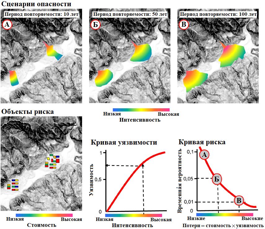
Для расчета риска могут использоваться два альтернативных типа анализа – детерминистический или вероятностный. При детерминистическом анализе рисков используются средние или наименее благоприятные (при наихудшем сценарии) значения компонентов риска (переменных уравнения риска) и получается одномерный результат, показывающий средний или максимальный риск соответственно. Напротив, для вероятностного анализа принимается, что все или некоторые компоненты риска соответствуют распределениям вероятностей, поэтому результаты представляются вероятностно – с использованием пар значений или графиков (кумулятивной) вероятности и последствий. Моделирование методом Монте-Карло может облегчить вероятностный расчет риска, если известны функции плотности вероятности, которые лучше всего соответствуют распределениям компонентов риска.
Оценка уязвимости
Несмотря на то что проводились обширные исследования по количественной оценке оползневой опасности, разработки по анализу последствий и оценке уязвимости были ограниченными. Далее будут описаны различные виды ущерба от разных типов оползней для разных объектов риска и приведены указания по выбору подходящих методов оценки уязвимости в зависимости от объекта риска, типа оползня и масштаба анализа.
Типы уязвимости
В разных дисциплинах используются разные определения и концептуальные парадигмы для уязвимости.
С точки зрения естественных наук, уязвимость может быть определена как степень потерь для определенного объекта или ряда объектов на территории, подверженной оползневому риску. Для имущества ущербом будет его величина в отношении стоимости. Для людей это будет вероятность их гибели. Уязвимость может также относиться к предрасположенности к потерям (или к вероятности потерь), а не к их степени.
В социальных науках существует множество определений и аспектов для термина «уязвимость» в зависимости от масштаба и цели анализа. Некоторые из них рассмотрены в публикациях [262, 302].
Количественная оценка уязвимости может быть получена: в денежном выражении (абсолютном или относительном касательно величины подверженных риску объектов), в процентах от валового внутреннего продукта на душу населения, в количестве смертельных исходов или с использованием других типов шкал показателей (последнее особенно актуально для социальной уязвимости, как описано в работе [303]). Степень ущерба, причиненного тем или иным событием, представляет собой сумму прямых и косвенных потерь. Здесь мы рассмотрим физическую уязвимость и уязвимость людей.
1. Физическая уязвимость относится к прямому ущербу для зданий, инженерных сетей и других объектов инфраструктуры. Финансовые последствия ущерба зданию или сооружению могут быть легко оценены и понятны. Кроме того, уязвимость физических объектов может быть выражена в отношении степени ущерба или стоимости восстановления в результате события.
2. Уязвимость людей (гибель, травмы) относится к тому, приведет ли оползневое событие к травмам или смертельным исходам или нет. Опять же, в случаях травм или гибели людей (в пересчете на страховую стоимость) или снижения качества жизни может быть дана денежная оценка. Модели, которые используются для определения таких денежных значений, как правило, учитывают стоимость спасения, госпитализации и лечения, а также потерю потенциальных заработков (как на ближайшее время в случае травмы, так и в долгосрочной перспективе). Гибель людей или получение ими травм в результате схода оползня приводят также и к социальным последствиям, которые нелегко поддаются количественной оценке.
Обзор типов потенциального ущерба, которые классифицируются в зависимости от типа оползня, объектов риска и расположения этих объектов по отношению к оползню, представлен в публикации [17].
Уязвимость зданий
Опыт показывает, что степень ущерба для зданий весьма различна в зависимости от характеристик здания, механизма оползня, а также его величины и интенсивности. Уязвимость может быть выражена в виде степени ущерба, варьирующей от неконструктивных повреждений до обширного разрушения/обрушения. Повреждения могут быть конструктивными/структурными или неконструктивными/неструктурными с нарушением инженерных систем.
Тип уязвимого объекта – ключевой фактор при оценке его уязвимости тем или иным методом. Основные типологические параметры, которые определяют способность зданий противостоять оползням – это конструктивная система, геометрия, свойства материалов, состояние технического обслуживания, уровни проектных норм, детали фундамента и наземной части, количество этажей и др. Стоимость ущерба зависит от типа здания, его расположения и использования. Для облегчения сбора данных в местном и региональном масштабах во многих случаях удобно рассматривать более агрегированные уровни в виде однородных объектов. Они должны включать группы зданий, характеризующихся относительной однородностью по типу конструкций, строительным материалам, возрасту, количеству этажей и распределению в отношении землепользования.
Дополнительным важным фактором является географическое расположение объектов по отношению к телу потенциального оползня (на уровне бровки срыва, зоны перемещения, фронтальной части и т.д.) с учетом вариаций движения и последующего взаимодействия со зданиями. Важными параметрами также являются место удара и его важность для устойчивости объекта. Основные места воздействия – крыша, фасад (включая структурные и неструктурные элементы) и фундамент. Для малых масштабов в силу небольшого разрешения анализа может быть принято упрощение, заключающееся в том, что события схожей величины вызывают повреждения одинакового уровня. При детальном масштабе оценки, особенно для камнепадов и обломочных потоков, следует учитывать точку удара по зданию, особенно по элементам, которые важны для его устойчивости. В особенности это касается каркасных конструкций, где, например, повреждение несушей колонны может инициировать каскад разрушений. В каменных конструкциях (из каменной, кирпичной или другой кладки) повреждения обычно носят локальный характер, поскольку легко находятся альтернативные пути для передачи нагрузки благодаря гиперстатической (с избыточными связями) несущей системе.
Один из основных параметров, способных существенно повлиять на повреждение здания в случае обломочного потока, – «иерархия сопротивлений» между основными конструктивными (несущими) и второстепенными неконструктивными (ненесущими) элементами.
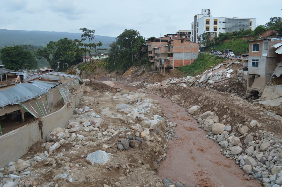
Ущерб, наносимый застроенной среде в результате возникновения быстрых оползней, таких как обломочные потоки и камнепады, как правило, является самым большим и серьезным, поскольку он может привести к полному разрушению любого здания. Однако медленно движущиеся оползни также оказывают неблагоприятное воздействие [264]. Ущерб, наносимый зданию медленным оползнем, в основном объясняется кумулятивным долговременным (абсолютным или дифференциальным) смещением и тем, что оно сосредоточено в пределах неустойчивой зоны. Тип реакции здания на долговременное общее и дифференциальное деформирование грунта зависит в первую очередь от типа фундамента. Глубокие фундаменты менее уязвимы, чем неглубокие. Жесткие фундаменты, которые допускают вращение здания как жесткого тела, могут быть менее уязвимыми, чем гибкие [304].
Уязвимость автомобильных и железных дорог и транспортных средств
Уязвимость системы автомобильных или железных дорог может быть обусловлена как частичной или полной блокировкой их трасс, так и структурными повреждениями, включая нарушение покрытия, что связано с уровнем эксплуатационной пригодности.
Для оценки уязвимости транспортной инфраструктуры и транспортных средств (из-за прерывания движения) по отношлению к различным оползневым опасностям необходима информация о типе (автомагистраль, асфальтированная или грунтовая дорога или др.), ширине дороги и интенсивности движения. В этих целях можно использовать среднегодовой показатель ежедневного движения (annual average daily traffic – AADT), который является репрезентативным для типичного транспортного потока.
Для движущихся объектов, таких как транспортные средства, точная оценка уязвимости требует хорошей регистрации прошлых оползневых событий и связанного с ними ущерба [74]. Уязвимость транспортного средства на дороге зависит от его положения по отношению к оползню в определенное время и от того, пострадает ли оно непосредственно от удара, врежется ли в уже отложенный материал или сойдет с рельсов из-за повреждения инфраструктуры. Кроме того, важными способствующими факторами являются: тип транспортного средства (в части его средней скорости), величина оползня и плотность (интенсивность) движения в определенное время на определенном участке дороги. Таким образом, уязвимость транспортного средства по отношению к оползням привязана к пространству и времени и может быть количественно определена с использованием статистических данных и/или стохастических подходов.
Уязвимость людей
Физическая уязвимость людей относится к вероятности того, что из-за оползня будет потеряна конкретная жизнь [11]. Она зависит от многих факторов: типа оползня, его размера и интенсивности; сопротивляемости и подвижности людей, подверженных оползневому риску; их относительного положения в зоне воздействия. Считается, что сопротивляемость человека воздействию оползней также является функцией его интеллектуальной зрелости (например, в отношении восприятия риска) и его физических данных (например, в силу возраста) [305]. Этот тип уязвимости может быть весьма важным в случае быстрого оползня (обломочного потока, камнепада), но, как правило, незначителен для медленных оползней. Из-за сложного и динамичного характера человеческой популяции такая уязвимость меняется во времени. Учитывая большие неопределенности и сложности, связанные с физической уязвимостью людей по отношению к оползням, все существующие методики ее анализа основываются на экспертных оценках и эмпирических данных.
Количественная оценка уязвимости
Уязвимость объекта риска может быть количественно оценена с помощью индексов или кривых уязвимости. Индекс уязвимости отражает степень ущерба по относительной шкале от нуля (отсутствие повреждений) до единицы (полное разрушение). Кривые уязвимости показывают условную вероятность достижения или превышения определенного уровня ущерба (например, незначительного, умеренного, обширного, полного) в результате схода оползня определенного типа и определенной интенсивности. Таким образом, в подход к моделированию уязвимости явно можно включить как эпистемологические (основанные на знаниях), так и случайные неопределенности (например, для структурной типологии, сопротивления материалов, возраста, состояния технического обслуживания и т.д.).
Большинство процедур построения кривых уязвимости, описанных в литературе (например, [306–310] и др.), первоначально было предложено в отношении землетрясений, но их также можно модифицировать так, чтобы применять при рассмотрении воздействий оползней. Для представления кривой уязвимости для заранее заданного уровня повреждений (или предельного состояния) обычно используется функция двухпараметрического логнормального распределения из-за ее простой параметрической формы [311, 312].
Методы, используемые для количественной оценки уязвимости, в соответствии с типом входных данных и оценкой параметров динамического отклика объекта можно разделить на три группы: эвристические (основанные на суждениях экспертов) (таблица 16); основанные на данных, то есть использующие данные прошлых событий (таблица 17); аналитические, то есть использующие физические модели (таблица 18). Наличие и качество входных данных также играют фундаментальную роль.
Таблица 16. Эвристические (основанные на суждениях экспертов) методы оценки уязвимости
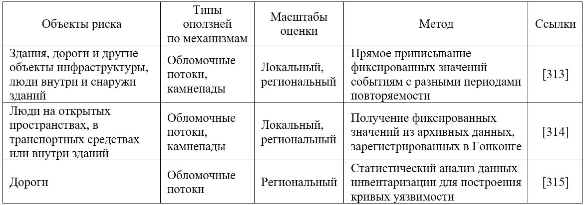
Таблица 17. Методы оценки уязвимости, основанные на данных
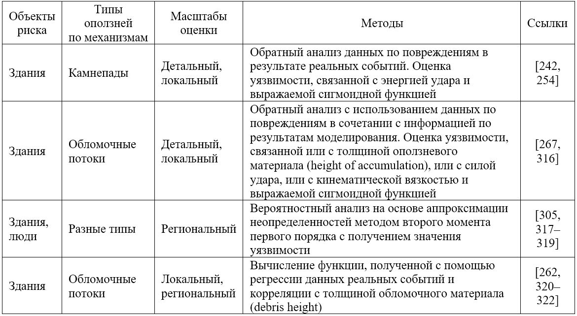
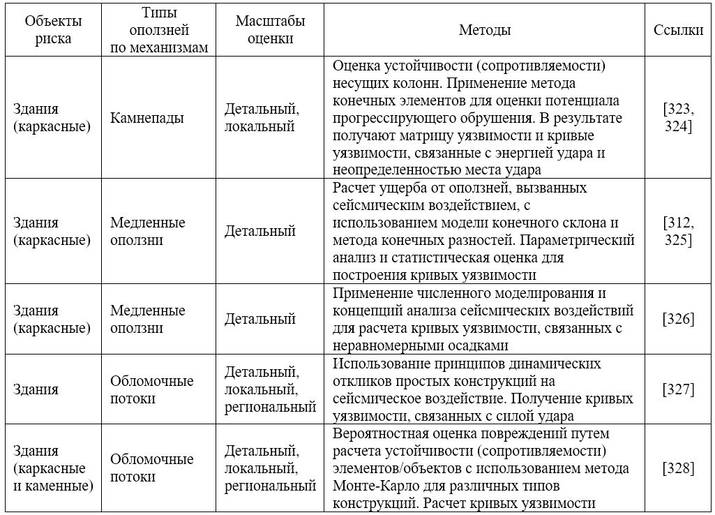
Таблица 18. Аналитические методы оценки уязвимости (основанные на физических моделях)
Эвристические (основанные на суждениях экспертов) методы
Эвристические (основанные на суждениях экспертов) методы обычно дают дискретные значения для диапазона интенсивностей оползней. Основываясь на экономической ценности зданий, дорог и других объектов инфраструктуры в заданном районе, авторы работы [313] установили фиксированные значения уязвимости в зависимости от периода повторяемости обломочных потоков и камнепадов. Таким же образом они определили значения уязвимости для людей внутри и снаружи зданий. Для людей, находящихся на открытых пространствах, в транспортных средствах или в зданиях в оползнеопасных зонах, на основе наблюдений за реальными событиями авторы публикации [314] дополнительно получили значения, которые могут быть использованы для оценки рисков в Гонконге.
В работе [315] был предложен метод определения физического ущерба дорогам из-за обломочных потоков на основе статистического анализа данных из анкет (заполненных признанными экспертами в области оценки опасностей и рисков в связи с обломочными потоками) для расчета кривых уязвимости.
Методы, основанные на данных
Методы, основанные на данных, являются наиболее часто используемыми для оценки уязвимости, поскольку они отличаются простотой и надежностью, хотя и привносят определенную степень субъективности. Степени их сложности и учета неопределенностей значительно различаются, и их применимость ограничена необходимостью в наличии данных инвентаризации для исследуемой территории. Уязвимость с помощью этих методов рассчитывается как функция интенсивности оползня.
Авторы статьи [254] выполнили обратный анализ данных по повреждениям в результате реальных событий для получения корреляций между интенсивностью камнепадов и уязвимостью зданий с помощью регрессии. Результатом стала эмпирическая функция уязвимости для оценки в детальном масштабе, полученная путем подбора значений повреждений и энергий удара с помощью сигмоидной функции. Аналогичным образом в работе [316] были использованы данные инвентаризации ущерба, ненесенного зданиям обломочными потоками, для расчета сигмоидной функции, которая может быть использована для определения уязвимости в зависимости от толщины оползневого материала (height of accumulation), силы удара и кинематической вязкости.
В статьях [305, 317] в количественную оценку уязвимости были включены неопределенности. Была предложена вероятностная оценка уязвимости с помощью подхода, основанного на аппроксимации неопределенностей методом второго момента первого порядка (FOSM – first-order second moment), который использовался также в работе [318]. Схожая вероятностная модель была предложена и в публикации [319].
Для обломочных потоков авторы работ [262, 320–322] получили функцию уязвимости, которая связывает интенсивность (толщину обломочного материала) со значениями уязвимости.
Авторы статьи [267] разработали индекс интенсивности обломочного потока, который учитывает высоту и скорость потока, чтобы рассчитать вероятность ущерба.
Аналитические методы
Аналитические методы применяются реже из-за их сложности по сравнению с описанными выше методами и из-за отсутствия/нехватки детальных входных данных. При использовании таких методов обычно проводятся различия между зданиями, имеющими разные типы конструкций.
Уязвимость нижней части железобетонной конструкции к воздействиям камнепадов может быть проанализирована с помощью методики, представленной в публикациях [323, 324]. При ее использовании учитывается потенциальная возможность прогрессирующего обрушения, когда в результате камнепада разрушаются ключевые элементы конструкции (анализ выполняется с применением метода конечных элементов). Эта методика позволяет получить дискретные вероятностные значения уязвимости для разных интенсивностей событий и кривые уязвимости, учитывающие неопределенность места удара.
Авторы статей [312, 325] разработали аналитический метод оценки уязвимости железобетонных зданий, подверженных воздействию медленных оползней, вызванных землетрясениями. Кривые уязвимости были получены с помощью определения пиковых ускорений грунта или перманентных смещений в скальном основании, находящемся в сейсмически активной зоне, и вероятности превышения каждого предельного состояния на основе двухэтапного численного моделирования в несвязанной постановке. Этот метод применим к различным типам грунта, геометриям склонов и конфигурациям зданий, что позволяет явно учитывать разные источники неопределенности. В работе [326] также были рассчитаны кривые уязвимости в зависимости от неравномерных осадок железобетонного каркасного здания.
Кривые уязвимости могут быть получены для неармированных и армированных каменных конструкций, подверженных воздействию обломочных потоков, с помощью метода, предложенного в публикации [327], в пакете программ HAZUS [329]. В этом методе используются принципы динамического отклика простой конструкции на сейсмическое воздействие. Кроме того, авторы работы [328] представили другой аналитический метод расчета кривых уязвимости – основанный на оценке устойчивости (сопротивляемости) железобетонного каркаса и заполняющей его стены в вероятностных терминах и использующий моделирование методом Монте-Карло. При этом учитывается иерархия устойчивостей отдельных элементов конструкции.
Перевод статьи выполнен при поддержке ГК «ПЕТРОМОДЕЛИНГ» и Алексея Бершова.
-
Продолжение следует
ИСТОЧНИК ДЛЯ ПЕРЕВОДА
Corominas J., Van Westen C., Frattini P., Cascini L., Malet J.-P., Fotopoulou S., Catani F., Van Den Eeckhaut M., Mavrouli O., Agliardi F., Pitilakis K., Winter M.G., Pastor M., Ferlisi S., Tofani V., Hervas J., Smith J.T. Recommendations for the quantitative analysis of landslide risk // Bulletin of Engineering Geology and the Environment. 2014. Vol. 73. № 2. P. 209–263. DOI:10.1007/s10064-013-0538-8. URL: https://www.researchgate.net/publication/259032330_Recommendations_for_the_quantitative_analysis_of_landslide_risk.
СПИСОК ЛИТЕРАТУРЫ, ИСПОЛЬЗОВАННОЙ АВТОРАМИ ПЕРЕВЕДЕННОЙ СТАТЬИ
- Fell R., Corominas J., Bonnard Ch., Cascini L., Leroi E., Savage W.Z. Guidelines for landslide susceptibility, hazard and risk zoning for land use planning (on behalf of the JTC-1 Joint Technical Committee on Landslides and Engineered Slopes) // Eng. Geol. 2008. Vol. 102. P. 85–98.
- TC32 – Technical Committee 32 (Engineering Practice of Risk Assessment and Management) of the International Society of Soil Mechanics and Geotechnical Engineering (ISSMGE). Risk assessment – glossary of terms. 2004. URL: http://www.engmath.dal.ca/tc32/2004Glossary_Draft1.pdf.
- Terminology of disaster risk reduction. Geneva: United Nations International Strategy for Disaster Reduction (UN-ISDR). 2004. URL: http://www.unisdr.org/eng/library/lib-terminology-eng%20home.htm.
- Cruden D.M., Varnes D.J. Landslide types and processes // Landslides – investigation and mitigation: Transportation Research Board Special Report № 247 (ed. by A.T. Turner, R.L. Schuster). Washington, DC: National Academy Press, 1996. P. 36–75.
- Hungr O., Evans S.G., Bovis M.J., Hutchinson J.N. A review of the classification of landslides of the flow type // Environ. Eng. Geosci. 2001. Vol. VII. № 3. P. 221–238.
- Hungr O., Leroueil S., Picarelli L. Varnes classification of landslide types, an update // Eberhardt E., Froesse C., Turner A.K., Leroueil S. (eds.). Landslides and engineered slopes: protecting society through improved understanding. Boca Raton: CRC Press, 2012. Vol. 1. P. 47–58.
- IAEG Commission on Landslides. Suggested nomenclature for landslides // Bull. Int. Assoc. Eng. Geol. 1990. Vol. 41. P. 13–16.
- Petley D.N. Landslides and engineered slopes: protecting society through improved understanding // Eberhardt E., Froese C., Turner A.K., Leroueil S. (eds.). Landslides and engineered slopes. London: CRC, 2012. Vol. 1. P. 3–13.
- OFAT, OFEE, OFEFP. Recommandations 1997: prise en compte des dangers dus aux mouvements de terrain dans le cadre des activites de l’amenagement du territoire. Berne: OCFIM, 1997. 42 p.
- Assessment of landslide risk in natural hillsides in Hong Kong: Report № 191. Hong Kong: Hong Kong Geotechnical Engineering Office (GEO), 2006. 117 p.
- AGS. Guidelines for landslide susceptibility, hazard and risk zoning for land use management // Aust. Geomech. Australian Geomechanics Society ( AGS) Landslide Taskforce Landslide Zoning Working Group, 2007. Vol. 42. № 1. P. 13–36.
- Fell R., Corominas J., Bonnard Ch., Cascini L., Leroi E., Savage W.Z. Guidelines for landslide susceptibility, hazard and risk zoning for land-use planning (on behalf of the JTC-1 Joint Technical Committee on Landslides and Engineered Slopes) // Comment. Eng. Geol. 2008. Vol. 102. P. 99–111.
- Corominas J. et al. (eds.) SafeLand Deliverable D2.1: overview of landslide hazard and risk assessment practices. 2010. URL: http://www.safeland-fp7.eu/.
- Lee E.M., Jones D.K.C. Landslide risk assessment. London: Thomas Telford, 2004. 454 p.
- Glade T., Anderson M., Crozier M.J. Landslide hazard and risk. Chichester: Wiley, 2005. 802 p.
- Smith K., Petley D.N. Environmental hazards: assessing risk and reducing disaster. London: Taylor & Francis, 2008.
- Van Westen C.J., Van Asch T.W.J., Soeters R. Landslide hazard and risk zonation: why is it still so difficult? // Bull. Eng. Geol. Environ. 2005. Vol. 65. P. 167–184.
- IUGS Working Group on Landslides, Committee on Risk Assessment. Quantitative risk assessment for slopes and landslides – the state of the art // Cruden D., Fell R. (eds.). Landslide risk assessment. Amsterdam: A.A. Balkema, 1997. P. 3–12.
- Brabb E.E., Pampeyan E.H., Bonilla M.G. Landslide susceptibility in San Mateo County, California // Misc. Field Studies, map MF-360 (scale 1:62500). Reston: US Geological Survey, 1972.
- Humbert M. Les mouvements de terrains // Principes de realisation d’une carte previsionnelle dans les Alpes // Bull. du BRGM. Sect. III. 1972. Vol. 1. P. 13–28.
- Kienholz H. Map of geomorphology and natural hazards of Grindelwald, Switzerland, scale 1:10000 // Artic Alp. Res. 1978. Vol. 10. P. 169–184.
- Brand E.W. Special lecture: landslide risk assessment in Hong Kong // Proceedings of the V International Symposium on Landslides, Lausanne, Switzerland. Amsterdam: A.A. Balkema, 1988. Vol. 2. P. 1059–1074.
- Wong H.N., Chen Y.M., Lam K.C. Factual report on the November 1993 natural terrain landslides in three study areas on Lantau Island: GEO Report № 61. Hong Kong: Geotechnical Engineering Office (GEO), 1997. 42 p.
- Hardingham A.D., Ho K.K.S., Smallwood A.R.H., Ditchfield C.S. Quantitative risk assessment of landslides – a case history from Hong Kong // Proceedings of the seminar on geotechnical risk management. Geotechnical Division, Hong Kong, 1998. Hong Kong: Hong Kong Institution of Engineers, 1998. P. 145–152.
- Wong H.N., Ho K.K.S. Overview of risk of old man-made slopes and retaining walls in Hong Kong // Proceedings of the Seminar on Slope Engineering in Hong Kong, Hong Kong, 1998. Hong Kong: A.A. Balkema, 1998. P. 193–200.
- Ho K.K.S,, Leroi E., Roberds B. Quantitative risk assessment – application, myths and future direction // Proceedings of the International Conference on Geotechnical and Geological Engineering (GeoEng2000), Melbourne, Australia, 9–24 November 2000. Vol. 1. P. 269–312.
- Wong H.N. Landslide risk assessment for individual facilities – state of the art report // Hungr O., Fell R., Couture R., Eberhardt E. (eds.) Proceedings of the International Conference on Landslide Risk Management. London: Taylor & Francis, 2005. P. 237–296.
- AGS. Landslide risk management concepts and guidelines // Aust. Geomech. Australian Geomechanics Society (AGS), 2000. Vol. 35. № 1. P. 49–92.
- Cascini L. Applicability of landslide susceptibility and hazard zoning at different scales // Eng, Geol, 2008. Vol. 102. P. 164–177.
- Cascini L., Bonnard Ch., Corominas J., Jibson R., Montero-Olarte J. Landslide hazard and risk zoning for urban planning and development – state of the art report // Hungr O., Fell R., Couture R., Eberhardt E. (eds.). Landslide risk management. Amsterdam: A.A. Balkema, 2005. P. 199–235.
- Nadim F., Kjeksta O. Assessment of global high-risk landslide disaster hotspots // Sassa K., Canuti P. (eds.). Landslides – disaster risk reduction. Berlin: Springer, 2009. P. 213–221.
- Nadim F., Kjekstad O., Peduzzi P., Herold C., Jaedicke C. Global landslide and avalanche hotspots // Landslides. 2006. Vol. 3. № 2. P. 159–174.
- Fell R., Ho K.K.S., Lacasse S., Leroi E. A framework for landslide risk assessment and management // Hungr O., Fell R., Couture R., Eberhardt E. (eds.). Landslide risk management. London: Taylor and Francis, 2005. P. 3–26.
- Soeters R., Van Westen C.J. Slope instability recognition, analysis and zonation // Turner A.K., Schuster R.L. (eds.). Landslides investigation and mitigation: TRB Special Report 247. Washington, DC: National Academy Press, 1996. P. 129–177.
- Leroi E., Bonnard Ch., Fell R., McInnes R. Risk assessment and management – state of the art report // Hungr O., Fell R., Couture R., Eberhardt E. (eds.). Landslide risk management. Amsterdam: A.A. Balkema, 2005. P. 159–198.
- Van Westen C.J., Castellanos Abella E.A., Sekha L.K. Spatial data for landslide susceptibility, hazards and vulnerability assessment: an overview// Eng. Geol. 2008. Vol. 102. № 3–4. P. 112–131.
- Crosta G.B., Agliardi F., Frattini P., Sosoi R. (eds.). SafeLand Deliverable 1.1: landslide triggering mechanisms in Europe – overview and state of the art. Identification of mechanisms and triggers. 2012. URL: http://www.safeland-fp7.eu/.
- Glade T., Crozier M.J. A review of scale dependency in landslide hazard and risk analysis // Glade T., Anderson M., Crozier M.J. (eds.). Landslide hazard and risk. London: Wiley, 2005. P. 75–138.
- Turner A.K., Schuster L.R. (eds.). Landslides, investigation and mitigation: Transportation Research Board Special Report 247. Washington, DC: National Research Council, National Academy Press, 1996. 673 p.
- Springman S., Seward L., Casini F., Askerinejad A., Malet J.-P., Spickerman A., Travelletti J. (eds.). SafeLand Deliverable D1.3: analysis of the results of laboratory experiments and of monitoring in test sites for assessment of the slope response to precipitation and validation of prediction models. 2011. URL: http://www.safeland-fp7.eu/.
- Jongmans D., Garambois S. Geophysical investigation of landslides: a review // Bull. Soc. Geol. France. 2007. Vol. 178. P. 101–112.
- Corominas J., Moya J. A review of assessing landslide frequency for hazard zoning purposes // Eng. Geol. 2008. Vol. 102. P. 193–213.
- Cepeda J., Colonnelli S., Meyer N.K., Kronholm K. SafeLand Deliverable D1.5: statistical and empirical models for prediction of precipitation-induced landslides. 2012. URL: http://www. safeland-fp7.eu/.
- Pitilakis K., Fotopoulou S. et al. (eds.). SafeLand Deliverable D2.5: physical vulnerability of elements at risk to landslides: methodology for evaluation, fragility curves and damage states for buildings and lifelines. 2011. URL: http://www.safeland-fp7.eu/.
- Metternicht G., Hurni L., Gogu R. Remote sensing of landslides: an analysis of the potential contribution to geo-spatial systems for hazard assessment in mountainous environments // Remote Sens. Environ. 2005. Vol. 98. № 23. P. 284–303.
- Singhroy V. Remote sensing of landslides // Glade T., Anderson M., Crozier M.J. (eds.). Landslide hazard and risk. Chichester: Wiley, 2005. P. 469–492.
- Kaab A. Photogrammetry for early recognition of high mountain hazards: new techniques and applications // Phys. Chem. Earth. Part B. 2010. Vol. 25. № 9. P. 765–770.
- Michoud C., Abellan A., Derron M.H., Jaboyedoff M. (eds.). SafeLand Deliverable D4.1: review of techniques for landslide detection, fast characterization, rapid mapping and long-term monitoring. 2010. URL: Available at http://www.safeland-fp7.eu/.
- Stumpf A., Malet J.-P. Kerle N. SafeLand Deliverable D4.3: creation and updating of landslide inventory maps, landslide deformation maps and hazard maps as inputs for QRA using remote-sensing technology. 2011. URL: http://www.safeland- fp7.eu/.
- WP/WLI. A suggested method for describing the activity of a landslide // Bull. Int. Assoc. Eng. Geol. 1993. Vol. 47. P. 53–57.
- Guzzetti F., Mondini A.S., Cardinali M., Fiorucci F., Santangelo M., Chan K.T. Landslide inventory maps: new tools for an old problem // Earth. Sci. Rev. 2012. Vol. 112. P. 42–66.
- Cardinali M. A geomorphological approach to the estimation of landslide hazards and risk in Umbria, Central Italy // Nat. Hazards Earth. Syst. Sci. 2002. Vol. 2. P. 57–72.
- Haugerud R.A., Harding D.J., Johnson S.Y., Harless J.L., Weaver C.S., Sherrod B.L. High-resolution LiDAR topography of the Puget Lowland. Washington – a bonanza for earth science // GSA Today. 2003. Vol. 13. P. 4–10.
- Ardizzone F., Cardinali M., Galli M., Guzzetti F., Reichenbach P. Identification and mapping of recent rainfall-induced landslides using elevation data collected by airborne Lidar // Nat. Hazards Earth. Syst. Sci. 2007. Vol. 7. P. 637–650.
- Van Den Eeckhaut M., Reichenbach P., Guzzetti F., Rossi M., Poesen J. Combined landslide inventory and susceptibility assessment based on different mapping units: an example from the Flemish Ardennes, Belgium // Nat. Hazards Earth. Syst. Sci. 2009. Vol. 9. № 2. P. 507–521.
- Razak K.A., Straatsma M.W., van Westen C.J., Malet J.-P., de Jong S.M. Airborne laser scanning of forested landslides characterization: terrain model quality and visualization // Geomorphology. 2011. Vol. 126. P. 186–200.
- Hervas J., Barredo J.I., Rosin P.L., Pasuto A., Mantovani F., Silvano S. Monitoring landslides from optical remotely sensed imagery: the case history of Tessina landslide, Italy // Geomorphology. 2003. Vol. 54. P. 63–75.
- Borghuis A.M., Chang K., Lee H.Y. Comparison between automated and manual mapping of typhoon-triggered landslides from SPOT-5 imagery // Int. J. Remote. Sens. 2007. Vol. 28. P. 1843–1856.
- Mondini A.C., Guzzetti F., Reichenbach P., Rossi M., Cardinali M., Ardizzone M. Semiautomatic recognition and mapping of rainfall induced shallow landslides using optical satellite images // Remote Sens. Environ. 2011. Vol. 115 . № 7 . P. 1743–1757.
- Martha T.R., Kerle N., Jetten V., van Westen C.J., Kumar K.V. Characterising spectral, spatial and morphometric properties of landslides for semi-automatic detection using object-oriented methods // Geomorphology. 2010. Vol. 116. № 1–2. P. 24–36.
- Lu P., Stumpf A., Kerle N., Casagli N. Object-oriented change detection for landslide rapid mapping // IEEE Geosci. Remote Sens. Lett. 2011. Vol. 99. P. 701–705.
- Travelletti J., Malet J.-P., Schmittbuhl J., Toussaint R., Delacourt C., Stumpf A. A multi-temporal image correlation method to characterize landslide displacements // Ber. Geol. B.-A. 2010. Vol. 82. P. 50–57.
- Niethammer U., James M.R., Rothmund S., Travelletti J., Joswig M. UAV-based remote sensing of the Super-Sauze landslide: evaluation and results // Eng. Geol. 2012. Vol. 128. P. 2–11. DOI: 10.1016/j.enggeo.2011.03.012.
- Martha T.R., Kerle N., Jetten V., van Westen C.J., Vinod Kumar K. Landslide volumetric analysis using Cartosat-1-derived DEMs // Geosci. Remote Sens. Lett. IEEE, 2010. Vol. 7. № 3. P. 582–586.
- Jaboyedoff M., Oppikofer T., Abellan A., Derron M.-H., Loye A., Metzger R., Pedrazzini A. Use of LIDAR in landslide investigations: a review // Nat. Hazards. 2012. Vol. 61. № 1. P. 5–28.
- Ferretti A., Prati C., Rocca F. Permanent scatterers in SAR interferometry // Trans. Geosci. Remote Sens. IEEE, 2001. Vol. 39. № 1. P. 8–20.
- Berardino P., Fornaro G., Lanari R., Sansosti E. A new algorithm for surface deformation monitoring based on small baseline differential interferograms // Trans. Geosci. Remote Sens. IEEE, 2002. Vol. 40. № 11. P. 2375–2383.
- Farina P., Colombo D., Fumagalli A., Marks F., Moretti S. Permanent scatters for landslide investigations: outcomes from the ESA-SLAM project // Eng. Geol. 2006. Vol. 88. P. 200–217.
- Farr T.G., Rosen P.A., Caro E., Crippen R., Duren R., Hensley S., Kobrick M., Paller M., Rodriguez E., Roth L., Seal D., Shaffer S., Shimada J., Umland J., Werner M., Oskin M., Burbank D., Alsdorf D. The Shuttle Radar Topography Mission // Rev. Geophys. 2007. Vol. 45. Issue RG2004. DOI:101029/2005RG000183.
- METI/NASA. ASTER Global Digital Elevation Model. Tokyo, Washington, DC: Ministry of Economy, Trade and Industry of Japan (METI), National Aeronautics and Space Administration (NASA), 2009. URL: http://asterweb.jpl.nasa.gov/gdem.asp; http://www.gdem.ersdac.jspacesystems.or.jp.
- Nelson A., Reute H.I., Gessler P. Chapter 3: DEM production methods and sources // Hengl T., Reute H.I. (eds.) Developments in soil science, vol. 33. Amsterdam: Elsevier, 2009. P. 65–85.
- Smith M.J., Pain C.F. Applications of remote sensing in geomorphology // Prog. Phys. Geogr. 2009. Vol. 33. № 4. P. 568–582.
- Aleotti P., Chowdhury R. Landslide hazard assessment: summary review and new perspectives // Bull. Eng. Geol. Environ. 1999. Vol. 58. P. 21–44.
- Dai F.C., Lee C.F., Ngai Y.Y. Landslide risk assessment and management: an overview // Eng. Geol. 2002 . Vol. 64. P. 65–87.
- Chacon J., Irigaray C., Fernandez T., El Hamdouni R. Engineering geology maps: landslides and geographical information systems // Bull. Eng. Geol. Environ. 2006. Vol. 65. P. 341–411.
- Dobbs M.R., Culshaw M.G., Northmore K.J., Reeves H.J., Entwisle D.C. Methodology for creating national engineering geological maps of the UK // Q. J. Eng. Geol. Hydrogeol. 2012 . Vol. 45. № 3. P. 335–347.
- Xie M, Tetsuro E, Zhou G., Mitani Y. Geographic Information Systems-based three-dimensional critical slope stability analysis and landslide hazard assessment // J. Geotech Geoenviron. Eng. 2003. Vol. 129. № 12. P. 1109–1118.
- Culshaw M.G. From concept towards reality: developing the attributed 3D geological model of the shallow subsurface // Q. J. Eng. Geol. Hydrogeol. 2005. Vol. 38. P. 231–284.
- Ghosh S., Gunther A., Carranza E.J.M., van Westen C.J., Jetten V.G. Rock slope instability assessment using spatially distributed structural orientation data in Darjeeling Himalaya (India) // Earth Surf. Proc. Land. 2010. Vol. 35. № 15. P. 1773–1792.
- Guimaraes R.F., Montgomery D.R., Greenberg H.M., Fernandes N.F., Trancoso Gomes R.A., de Carvalho J., Osmar A. Parameterization of soil properties for a model of topographic controls on shallow landsliding: application to Rio de Janeiro // Eng. Geol. 2003. Vol. 69. № 1–2. P. 99–108.
- Bakker M.M., Govers G., Kosmas C., Vanacker V., van Oost K., Rounsevell M. Soil erosion as a driver of land-use change // Agric. Ecosyst. Environ. 2005. Vol. 105. № 3. P. 467–481.
- Bathurst J.C., Moretti G., El-Hames A., Begueria S., Garcia-Ruiz J.M. Modelling the impact of forest loss on shallow landslide sediment yield, Ijuez river catchment, Spanish Pyrenees // Hydrol. Earth. Syst. Sci. 2007 . Vol. 11. № 1. P. 569–583.
- Talebi A., Troch P.A., Uijlenhoet R. A steady-state analytical slope stability model for complex hillslopes // Hydrol. Process. 2008. Vol. 22. № 4. P. 546–553.
- Montgomery D.R., Dietrich W.E. A physically based model for the topographic control on shallow landsliding // Water Resour .Res. 1994. Vol. 30. № 4. P. 1153–1171.
- Santacana N., Baeza B., Corominas J., De Paz A., Marturia J. A GIS-based multivariate statistical analysis for shallow landslide susceptibility mapping in La Pobla de Lillet area (Eastern Pyrenees, Spain) // Nat. Hazards. 2003. Vol. 30. P. 281–295.
- Dietrich W.E., Reiss R., Hsu M.L., Montgomery D.R. A process-based model for colluvial soil depth and shallow landsliding using digital elevation data // Hydrol. Process. 1995. Vol. 9. P. 383–400.
- D’Odorico P. A possible bistable evolution of soil thickness //. J. Geophys. Res. 2000. Vol. 105. № B11. P. 25927–25935.
- Tsai C.C., Chen Z.S., Duh C.T., Horng F.W. Prediction of soil depth using a soil-landscape regression model: a case study on forest soils in southern Taiwan // Natl. Sci. Counc. Repub. China. Part B. Life. Sci. 2001. Vol. 25. № 1. P. 34–39.
- Van Beek L.H. Assessment of the influence of changes in landuse and climate on landslide activity in a Mediterranean environment: Ph.D. thesis. Utrecht: University of Utrecht, 2002. 363 p.
- Penizek V., Boruvka L. Soil depth prediction supported by primary terrain attributes: a comparison of methods // Plant. Soil Environ. 2006. Vol. 52. № 9. P. 424–430.
- Catani F., Segoni S., Falorni G. Accurate basin scale soil depth modelling and its impact on shallow landslides prediction. European Geosciences Union General Assembly 2007, Vienna, Austria // Geophys. Res. Abstr. 2007. Vol. 9. P. 10828.
- Hengl T., Heuvelink G.B.M., Stein A. A generic framework for spatial prediction of soil variables based on regression-kriging // Geoderma. 2004. Vol. 120. № 1–2. P. 75–93.
- Kuriakose S.L., Devkota S., Rossiter D.G., Jetten V.J. Prediction of soil depth using environmental variables in an anthropogenic landscape, a case study in the Western Ghats of Kerala, India // Catena. 2009. Vol. 79. № 1. P. 27–38.
- Gustavsson M., Kolstrup E., Seijmonsbergen A.C. A new symbol-and-GIS-based detailed geomorphological mapping system: renewal of a scientific discipline for understanding landscape development // Geomorphology. 2006. Vol. 77. № 1-2. P. 90–111.
- Pike R.J. Geomorphometry – diversity in quantitative surface analysis // Prog. Phys. Geogr. 2000. Vol. 24 . № 1. P. 1–20.
- Asselen S.V., Seijmonsbergen A.C. Expert-driven semi-automated geomorphological mapping for a mountainous area using a laser DTM // Geomorphology. 2006. Vol. 78. № 3–4. P. 309–320.
- Matthews J.A., Brunsden D., Frenzel B, Glaser B., Weiss M.M. (eds.) Rapid mass movement as a source of climatic evidence for the Holocene // Palaeoclimate Res. 1997 . Vol. 19. 444 p.
- Van Beek L.P.H., Van Asch T.W.J. Regional assessment of the effects of land-use change and landslide hazard by means of physically based modelling // Nat. Hazards. 2004. Vol. 30. № 3. P. 289–304.
- Glade T. Landslide occurrence as a response to land use change: a review of evidence from New Zealand // Catena. 2003. Vol. 51. № 3–4. P. 297–314.
- Kuriakose S.L. Physically-based dynamic modelling of the effect of land use changes on shallow landslide initiation in the Western Ghats of Kerala, India: Ph.D. thesis. Utrecht: University of Utrecht, 2010. ISBN 978-90-6164-298-5.
- Crosta G.B., Frattini P. Distributed modelling of shallow landslides triggered by intense rainfall // Nat. Hazards Earth Syst. Sci. 2003. Vol. 3. № 1–2. P. 81–93.
- Collison A., Wade J., Griths S., Dehn M. Modelling the impact of predicted climate change on landslide frequency and magnitude in SE England // Eng. Geol. 2000. Vol. 55. P. 205–218.
- Melchiorre C., Frattini P. Modelling probability of rainfall-induced shallow landslides in a changing climate, Otta, Central Norway // Clim. Chang. 2012. Vol. 113. № 2. P. 413–436.
- Comegna L., Picarelli L., Bucchignani E., Mercogliano P. Potential effects of incoming climate changes on the behaviour of slow active landslides in clay // Landslides. 2012. Vol. 10. № 4. P. 373–391. DOI:101007/s10346-012-0339-3.
- Keefer D.K. Investigating landslides caused by earthquakes – a historical review // Surv. Geophys. 2002. Vol. 23. P. 473–510.
- Meunier P., Hovius N., Haines A.J. Regional patterns of earthquake-triggered landslides and their relation to ground motion // Geophys. Res. Lett. 2007. Vol. 34. № 20. Paper L20408.
- Gorum T., Fan X., van Westen C.J., Huang R.Q., Xu Q., Tang C., Wang G. Distribution pattern of earthquake-induced landslides triggered by the 12 May 2008 Wenchuan earthquake // Geomorphology. 2011 . Vol. 133. № 3–4. P. 152–167.
- Miles S.B., Keefer D.K. Evaluation of CAMEL – comprehensive areal model of earthquake-induced landslides // Eng. Geol. 2009. Vol. 104. P. 1–15.
- Alexander E.D. Vulnerability to landslides // Landslide risk assessment (ed. by T. Glade, M.G. Anderson, M.J. Crozier). London: Wiley, 2005. P. 175–198.
- Brenner C. Building reconstruction from images and laser scanning // Int. J. Appl. Earth Obs. Geoinf. 2005. Vol. 6. № 3–4. P. 187–198.
- Chen K., McAneney J., Blong R., Leigh R., Hunter L., Magill C. Defining area at risk and its effect in catastrophe loss estimation: a dasymetric mapping approach // Appl. Geogr. 2004. Vol. 24 . P. 97–117.
- Heuvelink G.B.M. Error propagation in environmental modelling with GIS. London: Taylor & Francis, 1998. 150 p.
- Fisher P.F., Tate N.J. Causes and consequences of error in digital elevation models // Prog. Phys. Geogr. 2006. Vol. 30. P. 467–489.
- Wechsler S.P. Uncertainties associated with digital elevation models for hydrologic applications: a review // Hydrol. Earth Syst. Sci. 2007. Vol. 11. P. 1481–1500.
- Ardizzone F., Cardinali M., Carrara A., Guzzetti F., Reichenbach P. Impact of mapping errors on the reliability of landslide hazard maps // Nat. Hazards Earth Syst. Sci. 2002. Vol. 2. P. 3–14.
- Van Den Eeckhaut M., Hervas J. State of the art of national landslide databases in Europe and their potential for assessing landslide susceptibility, hazard and risk // Geomorphology. 2012. Vol. 139-140. P. 545–558.
- Carrara A., Guzzetti F., Cardinali M., Reichenbach P. Use of GIS technology in the prediction and monitoring of landslide hazard // Nat. Hazards. 1999. Vol. 20. № 2–3. P. 117–135.
- Guzzetti F., Carrara A., Cardinali M., Reichenbach P. Landslide hazard evaluation: a review of current techniques and their application in a multi-scale study // Central Italy Geomorphol. 1999. Vol. 31. № 1–4. P. 181 –216.
- Wieczorek G.F. Preparing a detailed landslide-inventory map for hazard evaluation and reduction // Bull. Assoc. Eng. Geol. 1984. Vol. 21. № 3. P. 337–342.
- Crozier M.J. Multiple occurrence regional landslide events in New Zealand: hazard management issues // Landslides. 2005. Vol. 2. P. 247–256.
- Reid L.M., Page M.J. Magnitude and frequency of landsliding in a large New Zealand catchment // Geomorphology. 2003. Vol. 49. P. 71–88.
- Guzzetti F., Cardinali M., Reichenbach P., Carrara A. Comparing landslide maps: a case study in the upper Tiber River Basin, central Italy // Environ. Manage. 2000. Vol. 25. № 3. P. 247–363.
- Jaiswal P., van Westen C.J. Estimating temporal probability for landslide initiation along transportation routes based on rainfall thresholds // Geomorphology. 2009. Vol. 112. P. 96–105.
- Squarzoni C., Delacourt C., Allemand P. Nine years of spatial and temporal evolution of the La Vallette landslide observed by SAR interferometry // Eng. Geol. 2003. Vol. 68. P. 53–66.
- Colesanti C., Wasowski J. Investigating landslides with space-borne Synthetic Aperture Radar (SAR) interferometry // Eng. Geol. 2006. Vol. 88. P. 173–199.
- Coe J.A., Michael J.A., Crovelli R.A., Savage W.A. Preliminary map showing landslides densities, mean recurrence intervals, and exceedance probabilities as determined from historic records: open-file report 00-303. Seattle: USGS, 2000.
- Bulut F., Boynukalin S., Tarhan F., Ataoglu E. Reliability of isopleth maps // Bull. Eng. Geol. Environ. 2000. Vol. 58 . P. 95–98.
- Valadao P., Gaspar J.L., Queiroz G., Ferreira T. Landslides density map of S. Miguel Island, Azores Archipelago // Nat. Hazards Earth Syst. Sci. 2002. Vol. 2. P. 51–56.
- Lee S. Application of logistic regression model and its validation for landslide susceptibility mapping using GIS and remote sensing data // Int. J. Remote Sens. 2005. Vol. 26. № 7. P. 1477–1491.
- Yin K.J., Yan T.Z. Statistical prediction model for slope instability of metamorphosed rocks // Proc. 5th Int. Symp. on Landslides, Lausanne, Switzerland, 10–15 July 1988. Vol. 2. P. 1269–1272.
- Van Westen C.J. Application of geographic information systems to landslide hazard zonation: Ph.D. dissertation, ITC publ. № 15. Enschede: ITC, 1993. 245 p.
- Bonham-Carter G.F. Geographic information system for geoscientists: modelling with GIS. Oxford: Pergamon, 1994. 398 p.
- Suzen M.L., Doyuran V. Data driven bivariate landslide susceptibility assessment using geographical information systems: a method and application to Asarsuyu catchment // Turk. Eng. Geol. 2004. Vol. 71. P. 303–321.
- Chung C.F., Fabbri A.G. Representation of geoscience data for information integration // J. Non-Renew. Resour. 1993. Vol. 2. № 2. P. 122–139.
- Luzi L. Application of favourability modelling to zoning of landslide hazard in the Fabriano Area, Central Italy // Proc. First Joint Eur. Conf. & Exhibition on Geographical Information, The Hague, Netherlands, 26–31 March 1995. P. 398–402.
- Carrara A. Multivariate models for landslide hazard evolution // Math. Geol. 1983. Vol. 15. P. 403–427.
- Gorsevski P.V., Gessler P., Foltz R.B. Spatial prediction of landslide hazard using discriminant analysis and GIS // GIS in the Rockies 2000: Conference and Workshop: Applications for the 21st Century, Denver, CO, USA, 25–27 September 2000. URL; https://studylib.net/doc/12343493/gis-in-the-rockies-2000-conference-and-workshop.
- Ohlmacher G.C., Davis J.C. Using multiple logistic regression and GIS technology to predict landslide hazard in northeast Kansas // USA Eng. Geol. 2003. Vol. 69. № 33 . P. 331–343.
- Gorsevski P.V., Gessler P.E., Foltz R.B., Elliot W.J. Spatial prediction of landslide hazard using logistic regression and ROC analysis // Trans. GIS. 2006. Vol. 10. № 3. P. 395–415.
- Lee S., Ryu J.-H., Won J.-S., Park H.-J. Determination and application of the weights for landslide susceptibility mapping using an artificial neural network // Eng. Geol. 2004. Vol. 71 . № 3–4. P. 289–302.
- Ermini L., Catani F., Casagli N. Artificial neural networks applied to landslide susceptibility assessment // Geomorphology. 2005. Vol. 66. P. 327–343.
- Kanungo D.P., Arora M.K., Sarkar S., Gupta R.P. A comparative study of conventional, ANN black box, fuzzy and combined neural and fuzzy weighting procedures for landslide susceptibility zonation in Darjeeling Himalayas // Eng. Geol. 2006. Vol. 85. № 3–4 . P. 347–366.
- Pack R.T., Tarboton D.G., Goodwin C.N. The SINMAP approach to terrain stability mapping // 8th Congr. Int. Assoc. Eng. Geol., Vancouver, Canada, 21–25 September 1998.
- Baum R.L., Savage W.Z., Godt J.W. TRIGRS - a FORTRAN program for transient rainfall infiltration and grid-based regional slope stability analysis: US Geological Survey Open-File Report 02-0424. 2002. URL: http://pubs.usgs.gov/of/2002/ofr-02-424/.
- Casadei M., Dietrich W.E., Mille N.L. Testing a model for predicting the timing and location of shallow landslide initiation on soil mantled landscapes // Earth Surf. Proc. Land. 2003. Vol. 28. № 9. P. 925–950.
- Simoni S., Zanotti F., Bertoldi G., Rigon R. Modelling the probability of occurrence of shallow landslides and channelized debris flows using GEOtop-FS // Hydrol. Process. 2008. Vol. 22. P. 532–545.
- Jibson R.W., Harp E.L., Michael J.A. A method for producing digital probabilistic seismic landslide hazard maps: an example from the Los Angeles, California, area: open file report. Reston, USA: US Geological Survey, 1998. P. 98–113.
- Wang K.L., Lin M.I. Development of shallow seismic landslide potential map based on Newmark’s displacement: the case study of Chi-Chi earthquake, Taiwan // Environ. Earth Sci. 2010. Vol. 60. P. 775–785.
- Gunther A. SLOPEMAP: programs for automated mapping of geometrical and kinematical properties of hard rock hill slopes // Comput. Geosci. 2003. Vol. 29. P. 865–875.
- GEO-SLOPE. SLOPE/W. Calgary, Canada: GEO-SLOPE International, 2011. URL: http://www.geo-slope.com.
- Hungr O. A model for the run out analysis of rapid flow slides, debris flows and avalanches // Can. Geotech. J. 1995. Vol. 32. P. 610–623.
- Gitirana Jr.G., Santos M., Fredlund M. Three-dimensional slope stability model using finite element stress analysis // GeoCongress 2008, NewOrleans, LA, USA, 9–12 March 2008. P. 191–198.
- Hoek E., Grabinsky M.W., Diederichs M.S. Numerical modelling for underground excavations // Trans. Inst. Min. Metall. Sect. A. 1993. Vol. 100. P. A22–A30.
- Stead D., Eberhardt E., Coggan J., Benko B. Advanced numerical techniques in rock slope stability analysis: applications and limitations // LANDSLIDES – Causes, Impacts and Countermeasures, Davos, Switzerland, 17–21 June 2001. P. 615–624.
- Hart R.D. An introduction to distinct element modelling for rock engineering // Hudson J.A. (ed). Comprehensive rock engineering. Oxford: Pergamon, 1993.
- Horton P., Jaboyedoff M., Bardou E. Debris flow susceptibility mapping at a regional scale // Proceedings of the 4th Canadian Conference on Geohazards: From Causes to Management. Quebec, Canada: Presse de l’Universite Laval, 2008. P. 399–406.
- Hungr O., Corominas J., Eberhardt E. Estimating landslide motion mechanism, travel distance and velocity: state of the art report // Hungr O., Fell R., Couture R., Eberhardt E. (eds.). Landslide risk management. Amsterdam: A.A. Balkema, 2005. P. 99–128.
- Hoblitt R.P., Walder J.S., Driedger C.L., Scott K.M., Pringle P.T., Vallance J.W. Volcano hazards from Mount Rainier, Washington: revised open-file report 98-428. Reston: USGS, 1998.
- Corominas J., Copons R., Vilaplana J.M., Altimir J., Amigo J. Integrated landslide susceptibility analysis and hazard assessment in the principality of Andorra // Nat Hazards. 2003. Vol. 30 . P. 421–435.
- Ayala F.J., Cubillo S., Alvarez A., Dominguez M.J., Lain L., Lain R., Ortiz G. Large scale rockfall reach susceptibility maps in La Cabrera Sierra (Madrid) performed with GIS and dynamic analysis at 1:5000 // Nat Hazards. 2003. Vol. 30. P. 325–340.
- Jaboyedoff M. Conefall v.10: a program to estimate propagation zones of rockfall, based on cone method. Lausanne: Quanterra, 2003. URL: http://www.quanterra.com.
- Jaboyedoff M., Labiouse V. Preliminary assessment of rockfall hazard based on GIS data // ISRM 2003 «Technology Roadmap for Rock Mechanics», Gauteng, South Africa, 8–12 September 2003. P. 575–578.
- Prochaska A.B., Santi P.M., Higgins J.D., Cannon S.H. Debris-flow runout predictions based on the average channel slope (ACS) // Eng. Geol. 2008. Vol. 98. P. 29–40.
- Copons R., Vilaplana J.M. Rockfall susceptibility zoning at a large scale: from geomorphological inventory to preliminary land use planning // Eng. Geol. 2008. Vol. 102. P. 142–151.
- Li T. A mathematical model for predicting the extent of a major rockfall // Z. Geomorphol. 1983. Vol. 24. P. 473–482.
- Iverson R.M., Schilling S.P., Vallance J.W. Objective delineation of lahar-inundation hazard zones // Geol. Soc. Am. Bull. 1998. Vol. 110 . № 8. P. 972–984.
- Rickenmann D. Empirical relationships for debris flows // Nat. Hazards. 1999. Vol. 19. P. 47–77.
- Berti M., Simoni A. Prediction of debris flow inundation areas using empirical mobility relationships // Geomorphology. 2007. Vol. 90. P. 144–161.
- Fannin R.J., Wise M.P. An empirical-statistical model for debris flow travel distance // Can. Geotech. J. 2001. Vol. 38. P. 982–994.
- Domaas U. Geometrical methods of calculating rockfall range: report 585910-1. Oslo: Norwegian Geotechnical Institute, 1994.
- Hsu K.J. Catastrophic debris stream (sturzstroms) generated by rockfalls // Geol. Soc. Am. Bull. 1975. Vol. 86 . P. 129–140.
- Evans S.G., Hungr O. The assessment of rockfall hazard at the base of talus slopes // Can. Geotech. J. 1993. Vol. 30. P. 620–636.
- Scheidegger A. On the prediction of the reach and velocity of catastrophic landslides // Rock Mech. 1973. Vol. 5. P. 231–236.
- Finlay P.J., Mostyn G.R., Fell R. Landslide risk assessment: prediction of travel distance // Can. Geotech. J. 1999. Vol. 36. P. 556–562.
- Copons R., Vilaplana J.M., Linares R. Rockfall travel distance analysis by using empirical models (Sola d’Andorra la Vella, Central Pyrenees) // Nat. Hazards Earth Syst. Sci. 2009. Vol. 9. P. 2107–2118.
- Hungr O., Evans S.G. Engineering evaluation of fragmental rockfall hazards // Proceedings of the 5th International Symposium on Landslides. Lausanne: A.A. Balkema, 1988. Vol. 1. P. 685–690.
- Rickenmann D. Runout prediction methods // Jakob M., Hungr O. (eds.). Debris-flow hazards and related phenomena. Chichester: Praxis, 2005. P. 305–324.
- Crosta G.B., Cucchiaro S., Frattini P. Validation of semi-empirical relationships for the definition of debris-flow behaviour in granular materials // Proceedings of the 3rd International Conference on Debris-Flow Hazards Mitigation: Mechanics, Prediction and Assessment, Davos, Switzerland, 2003. Rotterdam: Millpress, 2003. P. 821–831.
- Jaboyedoff M., Dudt J.P., Labiouse V. An attempt to refine rockfall hazard zoning based on the kinetic energy, frequency and fragmentation degree // Nat. Hazards Earth Syst. Sci. 2005. Vol. 5. P. 621–632.
- Scheidl C., Rickenmann D. Empirical prediction of debris-flow mobility and deposition on fans // Earth Surf. Process. Landf. 2010. Vol. 35. P. 157–173.
- Piteau D.R., Clayton R. Computer rockfall model // Proc. Meeting on Rockfall Dynamics and Protective Work Effectiveness, ISMES, Bergamo, Italy, 20–21 May 1976. P. 123–125.
- Stevens W. RocFall: a tool for probabilistic analysis, design of remedial measures and prediction of rockfalls: MaSc thesis. Toronto: University of Toronto, 1998.
- Guzzetti F., Crosta G., Detti R., Agliardi F. STONE: a computer program for the three-dimensional simulation of rock-falls // Comput. Geosci. 2002. Vol. 28. P. 1081–1095.
- Guzzetti F., Malamud B.D., Turcotte D.L., Reichenbach P. Power-law correlations of landslide areas in central Italy // Earth Planet. Sci. Lett. 2002. Vol. 195. P. 169–183.
- Pfeiffer T.J., Bowen T.D. Computer simulations of rockfalls // Bull. Assoc. Eng. Geol. 1989 . Vol. 26. P. 135–146.
- Jones C.L., Higgins J.D., Andrew R.D. Colorado Rock Fall Simulation Program, version 40. Denver: Colorado Department of Transportation, Colorado Geological Survey, 2000.
- Crosta G.B., Agliardi F., Frattini P., Imposimato S. A three-dimensional hybrid numerical model for rockfall simulation // Geophys. Res. Abstr. 2004. Vol. 6. P. 04502.
- Bozzolo D., Pamini R. Simulation of rock falls down a valley side // Acta Mech. 1986. Vol. 63. P. 113–130.
- Azzoni A., La Barbera G., Zaninetti A. Analysis and prediction of rock falls using a mathematical model // Int. J. Rock Mech. Min. Sci. Geomech. Abstr. 1995. Vol. 32. P. 709–724.
- Calvetti F., Crosta G., Tatarella M. Numerical simulation of dry granular flows: from the reproduction of small-scale experiments to the prediction of rock avalanches // Rivista Italiana di Geotecnica. 2000. Vol. 2000. P. 21–38.
- Agliardi F., Crosta G.B. High resolution three-dimensional numerical modelling of rockfalls // Int. J. Rock Mech. Min. Sci. 2003. Vol. 40. P. 455–471.
- Dorren L.K.A., Seijmonsbergen A.C. Comparison of three GIS-based models for predicting rockfall runout zones at a regional scale // Geomorphology. 2003. Vol. 56. P. 49–64.
- Hutchinson J.N. A sliding-consolidation model for flow slides // Can. Geotech. J. 1986. Vol. 23. P. 115–126.
- Alonso E.E., Pinyol N.M. Criteria for rapid sliding I: a review of the Vaiont case // Eng. Geol. 2010. Vol. 114. P. 198–210.
- Pinyol N.M., Alonso E.E. Criteria for rapid sliding II: thermo-hydro-mechanical and scale effects in Vaiont case // Eng. Geol. 2010. Vol. 114. P. 211–227.
- Savage S.B., Hutter K. The dynamics of avalanches of granular materials from initiation to runout. Part I: Analysis // Acta Mech. 1991. Vol. 86. № 1–4 . P. 201–223.
- McDougall S., Hungr O. A model for the analysis of rapid landslide run out motion across three dimensional terrain // Can. Geotech. J. 2004. Vol. 41. P. 1084–1097.
- Pastor M., Haddad B., Sorbino G., Cuomo S., Drempetic V. A depth-integrated, coupled SPH model for flow-like landslides and related phenomena // Int. J. Numer. Anal. Meth. Geomech. 2009. Vol. 33. P. 143–172.
- Iverson R.I., Denlinger R.P. Flow of variably fluidized granular masses across three dimensional terrain. Coulomb mixture theory // J. Geophys. Res. 2001. Vol. 106. № B1. P. 537–552.
- Sosio R., Crosta G.B., Hungr O. Complete dynamic modelling calibration for the Thurwieser rock avalanche (Italian Central Alps) // Eng. Geol. 2008. Vol. 100. P. 11–26.
- Quecedo M., Pastor M., Herreros M.I., Fernandez Merodo J.A. Numerical modelling of the propagation of fast landslides using the finite element method // Int. J. Numer. Meth. Eng. 2004 . Vol. 59 . № 6. P. 755–794.
- Crosta G.B., Imposimato S., Roddeman D.G. Numerical modelling of entrainment/deposition in rock and debris-avalanches // Eng. Geol. 2008. Vol. 109. № 1–2. P. 135–145.
- Pastor M., Quecedo M., Fernandez Merodo J.A., Herreros M.I., Gonzalez E., Mira P. Modelling tailing dams and mine waste dumps failures // Geotechnique. 2002. Vol. LII. № 8. P. 579–592.
- Laigle D., Coussot P. Numerical modelling of mudflows // J. Hydraul. Eng. ASCE, 1997. Vol. 123. № 7. P. 617–623.
- Varnes D.J. Landslide hazard zonation: a review of principles and practice // Natural Hazard Series. UNESCO, Paris, 1984 . Vol. 3.
- Hungr O. Some methods of landslide hazard intensity mapping // Cruden D., Fell R. (eds.). Landslide risk assessment. Rotterdam: A.A. Balkema, 1997. P. 215–226.
- Guzzetti F., Galli M., Reichenbach P., Ardizzone F., Cardinali M. Landslide hazard assessment in the Collazzone area, Umbria, Central Italy // Nat. Hazards Earth. Syst. Sci. 2005. Vol. 6. P. 115–131.
- Crovelli R.A. Probabilistic models for estimation of number and cost of landslides: open file report 00-249. Reston: US Geological Survey, 2000. 23 p. URL: http://pubs.usgs.gov/of/2002/ofr-02-424/.
- Dussauge-Peisser C., Helmstetter A., Grasso J.-R., Hantz D., Desvarreux P., Jeannin M., Giraud A. Probabilistic approach to rock fall hazard assessment: potential of historical data analysis // Nat .Hazards Earth Syst. Sci. 2002 . Vol. 2. P. 15–26.
- Wong H.N., Ho K.K.S., Chan Y.C. Assessment of consequence of landslides // Cruden D., Fell R. (eds.). Landslide risk assessment. Rotterdam: A.A. Balkema, 1997. P. 111–149.
- Lee E.M., Brunsden D., Sellwood M. Quantitative risk assessment of coastal landslide problems // Bromhead E., Dixon N., Ibsen M.-L. (eds.). Landslides in Research Theory and Practice: proceedings of the 8th International Symposium on Landslides. London: Thomas Telford, 2000. Vol. 2. P. 899–904.
- Budetta P.B. Risk assessment from debris flows in pyroclastic deposits along a motorway, Italy // Bull. Eng. Geol. Environ. 2002. Vol. 61. № 4. P. 293–301.
- Wu T.H., Tang W.H., Einstein H.H. Landslide hazard and risk assessment // Turner A.T., Schuster R.L. (eds.). Landslides – investigation and mitigation: Transportation Research Board Special Report № 247. Washington, DC: National Academy Press, 1996. P. 106–118.
- Haneberg W.C. A rational probabilistic method for spatially distributed landslide hazard assessment // Environ. Eng. Geosci. 2004. Vol. X. P. 27–43.
- Wu T.H., Abdel-Latif M.A. Prediction and mapping of landslide hazard // Can. Geotech. J. 2000. Vol. 37. P. 781–795.
- Miller D.J., Sias J. Deciphering large landslides: linking hydrological groundwater and stability models through GIS // Hydrol. Process. 1998. Vol. 12. P. 923–941.
- Tacher L., Bonnard C., Laloui L., Parriaux A. Modelling the behaviour of a large landslide with respect to hydrogeological and geomechanical parameter heterogeneity // Landslides. 2005. Vol. 2. P. 3–14.
- Malet J.-P., van Asch Th.W.J., van Beek R., Maquaire O. Forecasting the behaviour of complex landslides with a spatially distributed hydrological model // Nat. Hazards Earth Syst. Sci. 2005 . Vol. 5. № 1. P. 71–85.
- Shrestha H.K., Yatabe R., Bhandary N.P. Groundwater flow modelling for effective implementation of landslide stability enhancement measures // Landslides. 2008. Vol. 5. P. 281–290.
- Iverson R.M. Landslide triggering by rain infiltration // Water Resour. Res. 2000. Vol. 36. P. 1897–1910.
- Baum R., Coe J.A., Godt J.W., Harp E.L., Reid M.E., Savage W.Z., Schulz W.H., Brien D.L., Chleborad A.F., McKenna J.P., Michael J.A. Regional landslide-hazard assessment for Seattle, Washington, USA // Landslides. 2005 . Vol. 2. P. 266–279.
- Godt J.W., Baum R.L., Savage W.Z., Salciarini D., Schulz W.H., Harp E.L. Transient deterministic shallow landside modelling: requirements for susceptibility and hazard assessment in a GIS framework // Eng. Geol. 2008. Vol. 102. P. 214–226.
- Guzzetti F., Peruccaci S., Rossi M., Stark C. Rainfall thresholds for the initiation of landslides in central and southern Europe. Meteorol Atmos Phys // 2007. Vol. 98. № 3. P. 239–267.
- Guzzetti F., Peruccaci S., Rossi M., Stark C. The rainfall intensity-duration control of shallow landslides and debris flows: an update // Landslides. 2008. Vol. 5. P. 3–17.
- Brabb E.E. Innovative approaches to landslide hazard mapping // Proceedings of the 4th International Symposium. on Landslides, Toronto, Canada, 16–21 September 1984 . Vol. 1. P. 307–324.
- Kramer S.L. Geotechnical earthquake engineering. Englewood Cliffs, NJ, USA: Prentice-Hall, 1996.
- Hovius N., Stark C.P., Allen P.A. Sediment flux from a mountain belt derived by landslide mapping // Geology. 1997. Vol. 25. P. 231–234.
- Pelletier J.D., Malamud B.D., Blodgett T., Turcotte D.L. Scale-invariance of soil moisture variability and its implications for the frequency-size distribution of landslides // Eng. Geol. 1997. Vol. 48. P. 255–268.
- Brardinoni F., Church M. Representing the landslide magnitude-frequency relation, Capilano River Basin, British Columbia // Earth Surf. Proc. Land. 2004. Vol. 29. P. 115–124.
- Malamud B.D., Turcotte D.L., Guzzetti F., Reichenbach P. Landslide inventories and their statistical properties // Earth Surf. Proc. Land. 2004. Vol. 29. P. 687–711.
- Guthrie R.H., Deadman P.J., Raymond Cabrera A., Evans S.G. Exploring the magnitude-frequency distribution: a cellular automata model for landslides // Landslides. 2008. Vol. 5. P. 151–159.
- Brunetti M.T., Guzzetti F., Rossi M. Probability distributions of landslide volumes // Nonlinear Process. Geophys. 2009. Vol. 16. P. 179–188.
- Hungr O., Evans S.G., Hazzard J. Magnitude and frequency of rock falls and rock slides along the main transportation corridors of south-western British Columbia // Can. Geotech. J. 1999. Vol. 36. P. 224–238.
- Stark C.P., Hovius N. The characterization of the landslide size distributions // Geophys. Res. Lett. 2001. Vol. 28. P. 1091–1094.
- Van Den Eeckhaut M., Poesen J., Govers G., Verstraeten G., Demoulin A. Characteristics of the size distribution of recent and historical landslides in a populated hilly region // Earth Planet. Sci. Lett. 2007. Vol. 256 . P. 588–603.
- Salciarini D., Godt J.W., Savage W.Z., Baum R.L., Conversini P. Modelling landslide recurrence in Seattle, Washington, USA // Eng. Geol. 2008. Vol. 102. № 3–4. P. 227–237.
- Guthrie R.H., Evans S.G. Analysis of landslide frequencies and characteristics in a natural system // Coast British Columbia Earth Surf. Process. Landf. 2004. Vol. 29. P. 1321–1339.
- Schuster R.L., Logan R.L., Pringle P.T. Prehistoric rock avalanches in the Olympic Mountains // Wash. Sci. 1992. Vol. 258. P. 1620–1621.
- Bull W.B., King J., Kong F., Moutoux T., Philips W.M. Lichen dating of coseismic landslide hazards in alpine mountains // Geomorphology. 1994. Vol. 10. P. 253–264.
- Bull W.B,. Brandon M.T. Lichen dating of earthquake-generated regional rockfall events, Southern Alps, New Zealand // GSA Bull. 1998. Vol. 110. P. 60–84.
- Van Steijn H. Debris-flow magnitude frequency relationships for mountainous regions of Central and Northern Europe // Geomorphology. 1996. Vol. 15. P. 259–273.
- Agliardi F., Crosta G.B., Zanchi A., Ravazzi C. Onset and timing of deep-seated gravitational slope deformations in the eastern Alps, Italy // Geomorphology. 2009. Vol. 103. P. 113–129.
- Lee E.M., Meadowcroft I.C., Hall J.W., Walkden M. Coastal landslide activity: a probabilistic simulation model // Bull. Eng. Geol. Environ. 2002. Vol. 61. P. 347–355.
- Bunce C.M., Cruden D.M., Morgenstern N.R. Assessment of the hazard from rock fall on a highway // Can. Geotech. J. 1997 . Vol. 34. P. 344–356.
- Chau K.T., Wong R.H.C., Liu J., Lee C.F. Rockfall hazard analysis for Hong Kong based on rockfall inventory // Rock Mech. Rock Eng. 2003. Vol. 36. P. 383–408.
- Jakob M., Friele P. Frequency and magnitude of debris flows on Cheekye River, British Columbia // Geomorphology. 2010. Vol. 114. P. 382–395.
- Stoffel M. Magnitude-frequency relationships of debris-flows – a case study based on field surveys and tree-ring records // Geomorphology. 2010. Vol. 116. P. 67–76.
- Corominas J., Moya J. Contribution of dendrochronology to the determination of magnitude-frequency relationships for landslides // Geomorphology. 2010. Vol. 124. P. 137–149. DOI:101016/jgeomorph 201009001.
- Lopez Saez J., Corona C., Stoffel M., Schoeneich P., Berger F. Probability maps of landslide reactivation derived from tree-ring records: Pra Bellon landslide, southern French Alps // Geomorphology. 2012. Vol. 138. P. 189–202.
- Van Dine D.F., Rodman R.F., Jordan P., Dupas J. Kuskonook Creek, an example of a debris flow analysis // Landslides. 2005. Vol. 2. № 4. P. 257–265. DOI:101007/s10346-005-0017.
- Jakob M. Morphometric and geotechnical controls of debris-flow frequency and magnitude in southwestern British Columbia: Ph.D. thesis. Vancouver: Geography Department, the University of British Columbia, 1996.
- Jakob M. The fallacy of frequency. Statistical techniques for debris flow frequency magnitude analysis // Proceedings of the International Landslide Conference, Banff, Canada, 2–8 June 2012. Vol. 1 . P. 741–750.
- Corominas J., Copons R., Moya J., Vilaplana J.M., Altimir J., Amigo J. Quantitative assessment of the residual risk in a rockfall protected area // Landslides. 2005. Vol. 2. P. 343–357.
- Agliardi F., Crosta G.B., Frattini P. Integrating rockfall risk assessment and countermeasure design by 3D modelling techniques // Nat. Hazards Earth Syst. Sci. 2009. Vol. 9. P. 1059–1073.
- Frattini P., Crosta G.B., Sosio R. Approaches for defining thresholds and return periods for rainfall-triggered shallow landslides // Hydrol. Process. 2009 . Vol. 23. № 10. P. 1444–1460.
- Crosta G.B., Agliardi F. A methodology for physically-based rockfall hazard assessment // Nat. Hazards. Earth Syst. Sci. 2003. Vol. 3. P. 407–422.
- Hungr O., McDougall S., Wise M., Cullen M. Magnitude-frequency relationships of debris flows and debris avalanches in relation to slope relief // Geomorphology. 2008. Vol. 96. P. 355–365.
- Jakob M. A size classification for debris flows // Eng. Geol. 2005. Vol. 79. P. 151–161.
- Bovolin V., Taglialatela L. Proceedings Scritti in onore di Lucio Taglialatela: CNR-GNDCI publ. № 2811. Perugia: CNR-GNDCI, 2002. P. 429–437.
- Calvo B., Savi F. A real-world application of Monte Carlo procedure for debris flow risk assessment // Comput. Geosci. 2009 . Vol. 35. № 5. P. 967–977.
- Borter P. Risikoanalyse bei gravitativen Naturgefahren. Bern: Bundesamt fur Umwelt, Wald und Landschaft, 1999.
- Fuchs S., Heiss K., Hubl J. Towards an empirical vulnerability function for use in debris flow risk assessment // Nat. Hazards Earth Syst. Sci. 2007. Vol. 7. P. 495–506.
- Saygili G., Rathje E.M. Probabilistically based seismic landslide hazard maps: an application in Southern California // Eng. Geol. 2009. Vol. 109. P. 183–194.
- Mansour M.F., Morgenstern N.I., Martin C.D. Expected damage from displacement of slow-moving slides // Landslides. 2011 . Vol. 8. № 1. P. 117–131.
- Archetti R., Lamberti A. Assessment of risk due to debris flow events // Nat. Hazards Rev. 2003. Vol. 4. № 3. P. 115–125.
- Friele P., Jakob M., Clague J. Hazard and risk from large landslides from Mount Meager Volcano, British Columbia, Canada // Georisk. 2008. Vol. 2. № 1. P. 48–64.
- Jakob M., Stein D., Ulmi M. Vulnerability of buildings to debris flow impact // Nat. Hazards. 2012. Vol. 60. P. 241–261.
- Gentile F., Bisantino T., Trisorio Liuzzi G. Debris-flow risk analysis in south Gargano watersheds (Southern Italy) // Nat. Hazards. 2008. Vol. 44. P. 1–17.
- Frattini P., Crosta G.B., Lari S., Agliardi F. Probabilistic rockfall hazard analysis (PRHA) // Eberhardt E., Froese C., Turner A.K., Leroueil S. (eds.). Landslides and engineered slopes: protecting society through improved understanding. London: Taylor & Francis, 2012. P. 1145–1151.
- Michoud C., Derron M.H., Hortin P., Jaboyedoff M., Baillifard F.J., Loye A., Nicolet P., Pedrazzini A., Queyrel A. Rockfall hazard and risk assessments along roads at a regional scale: example in Swiss Alps // Nat. Hazards Earth Syst. Sci. 2012. Vol. 12. P. 615–629.
- Jaiswal P., van Westen C.J., Jetten V. Quantitative assessment of direct and indirect landslide risk along transportation lines in southern India // Nat. Hazards Earth Syst. Sci. 2010. Vol. 10. № 6. P. 1253–1267.
- Roberds W. Estimating temporal and spatial variability and vulnerability // Hungr O., Fell R., Couture R., Eberhardt E. (eds.). Landslide risk management. London: Taylor & Francis, 2005. P. 129–158.
- Van Dine D.F., Rodman R.F., Jordan P., Dupas J. Kuskonook Creek, an example of a debris flow analysis // Landslides.2005. Vol. 2. № 4. P. 257–265. DOI:101007/s10346-005-0017.
- Keefer D.K. Landslides caused by earthquakes // Geol. Soc. Am. Bull. 1984. Vol. 95. № 4. P. 406–421.
- Govi M., Sorzana P.F. Landslide susceptibility as function of critical rainfall amount in Piedmont basins (North-Western Italy) // Studia Geomorphologica Carpatho-Balcanica. 1980. Vol. 14. P. 43–61.
- Baum R.L., Godt J.W. Early warning of rainfall-induced shallow landslides and debris flows in the USA // Landslides. 2010 . Vol. 7. P. 259–272.
- Crozier M.J., Preston N.J. Modelling changes in terrain resistance as a component of landform evolution in unstable hill country // Hergarten S., Neugebauer H.J. (eds.) Process modelling and landform evolution: lecture notes in earth sciences 78. Berlin: Springer, 1999. P. 267–284.
- Wilson R.A. The rise and fall of a debris flow warning system for the San Francisco Bay Region, California // Glade T., Anderson M., Crozier M.J. (eds.). Landslide hazard and risk. New York: Wiley, 2004. P. 493–516.
- Remondo J., Bonachea J., Cendrero A. A statistical approach to landslide risk modelling at basin scale: from landslide susceptibility to quantitative risk assessment // Landslides. 2005. Vol. 2. P. 321–328.
- Del Gaudio V., Pierri P., Wasowski J. An approach to time-probabilistic evaluation of seismically induced landslide hazard // Bull. Seismol. Soc. Am. 2003. Vol. 93. № 2. P. 557–569.
- Savage W.Z., God J.W., Baum R.L. Modelling time-dependent areal slope instability // Lacerda W., Ehrlich M., Fountoura S.A.B., Sayao A.S.F. (eds.). Landslide Evaluation and Stabilization: IX International Symposium on Landslides, Rio de Janeiro, 2004. Amsterdam: A.A. Balkema, 2004 . Vol. 1. P. 23–38.
- Baum R., Coe J.A., Godt J.W., Harp E.L., Reid M.E., Savage W.Z., Schulz W.H., Brien D.L., Chleborad A.F., McKenna J.P., Michael J.A. Regional landslide-hazard assessment for Seattle, Washington, USA // Landslides. 2005. Vol. 2. P. 266–279.
- Ferlisi S., Cascini L., Corominas J., Matano F. Rockfall risk assessment to persons travelling in vehicles along a road: the case study of the Amalfi coastal road (southern Italy) // Nat. Hazards. 2012. Vol. 62. № 2. P. 691–721.
- Guzzetti F., Reichenbach P., Wieczorek G.F. Rockfall hazard and risk assessment in the Yosemite Valley, California, USA // Nat. Hazards Earth Syst. Sci. 2003. Vol. 3 . P. 491–503.
- Blahut J., Horton P., Sterlacchini S., Jaboyedoff M. Debris flow hazard modelling on medium scale: Valtellina di Tirano, Italy // Nat. Hazards Earth Syst. Sci. 2010. Vol. 10. P. 2379–2390.
- Jaboyedoff M., Labiouse V. Preliminary estimation of rockfall runout zones // Nat. Hazards Earth Syst. Sci. 2011. Vol. 11. P. 819–828.
- Hurlimann M., Copons R., Altimir J. Detailed debris flow hazard assessment in Andorra: a multidisciplinary approach // Geomorphology. 2006. Vol. 78. № 3–4. P. 359–372.
- Hurlimann M., Rickenmann D., Medina V., Bateman A. Evaluation of approaches to calculate debris-flow parameters for hazard assessment // Eng. Geol. 2008. Vol. 102. P. 152–163.
- Catani F., Casagli N., Ermini L., Righini G., Menduni G. Landslide hazard and risk mapping at catchment scale in the Arno River basin // Landslides. 2005 . Vol. 2. P. 329–342.
- Abbruzzese J.M., Sauthier C., Labiouse V. Considerations on Swiss methodologies for rock fall hazard mapping based on trajectory modelling // Nat. Hazards Earth Syst. Sci. 2009. Vol. 9. P. 1095–1109.
- Lewis J. Multi-hazard history of Antigua // Disasters. 1984. Vol. 8. № 3. P. 190–197.
- Granger K., Jones T., Leiba M., Scott G. Community risks in Cairns: a multi-hazard risk assessment. Canberra: Australian Geological Survey Organisation, 1999.
- Van Westen C.J., Montoya L., Boerhoom L., Coto E.B. Multi-hazard risk assessment using GIS in urban areas: a case study for the city of Turrialba, Costa Rica // Proceedings of the Regional Workshop on Best Practices in Disaster Mitigation: Lessons Learned from the Asian Urban Disaster Mitigation Program and Other Initiatives, Bali, Indonesia, 24–26 September 2002. P. 53–72.
- Lacasse S., Eidsvik U., Nadim F., Hoeg K., Blikra L.H. Event tree analysis of Aknes rock slide hazard // Proceedings of the 4th Canadian Conf. on Geohazards, Quebec City, Canada, 20–24 May 2008. P. 551–557.
- Kappes M., Keiler M., Glade T. From single- to multi-hazard risk analyses: a concept addressing emerging challenges // Malet J.P., Glade T., Casagli N. (eds.) Proceedings of the Int. Conf. on Mountain Risks: Bringing Science to Society, Firenze, Italy, 24–26 November 2010. P. 351–356.
- Schmidt J., Matcham I., Reese S., King A., Bell R., Henderson R., Smart G., Cousins J., Smith W., Heron D. Quantitative multi-risk analysis for natural hazards: a framework for multi-risk modelling // Nat. Hazards. 2011 . Vol. 58. P. 1169–1192. DOI:101007/s11069-011-9721-z.
- Marzocchi W., Garcia-Aristizabal A., Gasparini P., Mastellone M.L., Di Ruocco A. Basic principles of multi-risk assessment: a case study in Italy // Nat. Hazards. 2012. Vol. 62. P. 551–573.
- Romeo R., Floris M., Veneri F. Area-scale landslide hazard and risk assessment // Environ. Geol. 2006. Vol. 51. P. 1–13.
- Cozzani V., Zanelli S. An approach to the assessment of domino accidents hazard in quantitative area risk analysis // Pasman H.J., Fredholm O., Jacobsson A. (eds.). Loss prevention and safety promotion in the process industries. Amsterdam: Elsevier, 2001. P. 1263–1274.
- Eveleigh T.J., Mazzucchi T.A., Sarkani S. Systems engineering design and spatial modelling for improved natural hazard risk assessment // Disaster Prev. Manag. 2006. Vol. 15. № 4. P. 636–648.
- Eveleigh T.J., Mazzucchi T.A., Sarkani S. Spatially-aware systems engineering design modelling applied to natural hazard vulnerability assessment // Syst. Eng. 2007. Vol. 10. № 3. P. 187–202.
- Tapsell S., McCarthy S., Faulkner H., Alexander M. Social vulnerability to natural hazards: CapHaz-Net WP4 Report. London: Flood Hazard Research Centre – FHRC, Middlesex University, 2010. URL: http://caphaz-net.org/outcomes-results/CapHaz-Net_WP4_Social-Vulnerability2.pdf.
- King D., MacGregor C. Using social indicators to measure community vulnerability to natural hazards // Aust. J. Emerg. Manag. 2000. Vol. 15. № 3. P. 52–57.
- Bird J.F., Bommer J.J., Crowley H., Pinho R. Modelling liquefaction-induced building damage in earthquake loss estimation // Soil Dyn. Earthq. Eng. 2006 . Vol. 26. № 1. P. 15–30.
- Uzielli M., Nadim F., Lacasse S., Kaynia A.M. A conceptual framework for quantitative estimation of physical vulnerability to landslides // Eng. Geol. 2008. Vol. 102. P. 251–256.
- ATC-13: Earthquake damage evaluation data for California. Redwood City: Applied Technology Council, 1985.
- Shinozuka M., Feng M.Q., Lee J., Naganuma T. Statistical analysis of fragility curves // J. Eng. Mech. ASCE, 2000. Vol. 126. № 12. P. 1224–1231.
- Cornell C.A., Jalayer F., Hamburger R.O., Foutch D.A. Probabilistic basis for 2000 SAC Federal Emergency Management Agency Steel Moment Frame Guidelines // J. Struct. Eng. 2002. Vol. 128. P. 526–533.
- Nielson B.G., DesRoches R. Analytical seismic fragility curves for typical bridges in the Central and Southeastern United States // Earthq. Spectra. 2007. Vol. 23. № 3. P. 615–633.
- Porter K., Eeri M., Kennedy R., Bachman R. Creating fragility functions for performance-based earthquake engineering // Earthq. Spectra. 2007. Vol. 23. № 2. P. 471–489.
- Koutsourelakis P.S. Assessing structural vulnerability against earthquakes using multi-dimensional fragility surfaces: a Bayesian framework // Probab. Eng. Mech. 2010. Vol. 25. P. 49–60.
- Fotopoulou S., Pitilakis K. Vulnerability assessment of reinforced concrete buildings subjected to seismically triggered slow-moving earth slides // Landslides. 2013. Vol. 10. P. 563–582. DOI:101007/s10346-012-0345-5.
- Bell R., Glade T. Quantitative risk analysis for landslides – examples from Bildudalur, NW-Iceland // Nat. Hazard. Earth Syst. Sci. 2004. Vol. 4. № 1. P. 117–131.
- Finlay P.J., Fell R.A. Study of landslide risk assessment for Hong Kong: School of Engineering Report. Sydney: The University of New South Wales, 1996.
- Winter M.G., Smith J., Fotopoulou S., Pitilakis K., Mavrouli O., Corominas J., Argyroudis S. Physical vulnerability of elements at risk to landslides: methodology for evaluation, fragility curves and damage states for buildings and lifelines // Submitted to Bull. Eng. Geol. Env. 2014.
- Quan Luna B., Blahut J., Van Westen C.J., Sterlacchini S., Van Asch T.W.J., Akbas S.O. The application of numerical debris flow modelling for the generation of physical vulnerability curves // Nat. Hazards Earth Syst. Sci. 2011. Vol. 11. P. 2047–2060. DOI:10.5194/nhess-11-2047-2011.
- Uzielli M., Lacasse S. Probabilistic estimation of vulnerability to landslides // Proceedings of the 13th Panamerican Conference on Soil Mechanics and Geotechnical Engineering, Margarita, Venezuela, 16–20 July 2007.
- Kaynia A.M., Papathoma-Kohle M., Neuhauser B., Ratzinger K., Wenzel H., Medina-Cetina Z. Probabilistic assessment of vulnerability to landslide: application to the village of Lichtenstein, Baden-Wurttemberg, Germany // Eng. Geol. 2008. Vol. 101. P. 33–48.
- Li Z., Nadim F., Huang H., Uzielli M., Lacasse S. Quantitative vulnerability estimation for scenario-based landslide hazards // Landslides. 2010. Vol. 7. № 2. P. 125–134.
- Fuchs S. Vulnerability to torrent events – empirical evidence from Austria // Geophys. Res. Abstr. 2008. Vol. 10. Article 04632. ISSN 1029-7006.
- Papathoma-Kohle M., Keiler M., Totschnig R., Glade T. Improvement of vulnerability curves using data from extreme events: a debris-flow event in South Tyrol // Nat. Hazards. 2012. Vol. 64. P. 2083–2105.
- Akbas S.O., Blahut J., Sterlacchini S. Critical assessment of existing physical vulnerability estimation approaches for debris flows // Malet J.P., Remaitre A., Bogaard T. (eds.). Proceedings of landslide processes: from geomorphologic mapping to dynamic modelling. Strasburg: CERG Editions, 2009. P. 229–233.
- Mavrouli O., Corominas J. Rockfall vulnerability assessment for reinforced concrete buildings // Nat. Hazards Earth Syst. Sci. 2010 . Vol. 10. P. 2055–2066.
- Mavrouli O., Corominas J. Vulnerability of simple reinforced concrete buildings in front of the rockfall impact // Landslides. 2010. Vol. 7. № 2. P. 169–180.
- Fotopoulou S., Pitilakis K. Fragility curves for reinforced concrete buildings to seismically triggered slow-moving slides // Soil Dyn. Earthq. Eng. 2013. Vol. 48. P. 143–161.
- Negulescu C., Foerster E. Parametric studies and quantitative assessment of the vulnerability of a RC frame building exposed to differential settlements // Nat. Hazards Earth. Syst. Sci. 2010. Vol. 10 . P. 1781–1792.
- Haugen E.D., Kaynia A.M. Vulnerability of structures impacted by debris flow // Chen Z.Y., Zhang J.M., Ho K., Wu F.Q., Li Z.K. (eds.). Landslides and engineered slopes. London: Taylor & Francis, 2008. P. 381–387.
- Zuccaro G., Santo F., De Gregorio D., Di Crescenzo G. Methodology for buildings at site specific to local scales // Safeland Deliverable D2.5: physical vulnerability of elements at risk to landslides: methodology for evaluation, fragility curves and damage states for buildings and lifelines. 2011. URL: http://www.safeland-fp7.eu/.
- NIBS. Earthquake loss estimation methodology HAZUS. Washington, DC: National Institute of Building Sciences, FEMA, 2004.
Журнал остается бесплатным и продолжает развиваться.
Нам очень нужна поддержка читателей.
Поддержите нас один раз за год
Поддерживайте нас каждый месяц