
Рекомендации по количественному анализу оползневых рисков. Часть 6

ВАН ВЕСТЕН К.
Факультет геоинформатики и наблюдений за Землей Университета Твенте, г. Энсхеде, Нидерланды
ФРАТТИНИ П.
Факультет наук о Земле и окружающей среде Миланского университета Бикокка, г. Милан, Италия
КАШИНИ Л.
Факультет гражданского строительства Университета Салерно, г. Салерно, Италия
МАЛЕ Ж.-П.
Национальный центр научных исследований при Страсбургском институте физики Земли, г. Страсбург, Франция
ФОТОПУЛУ С.
Отделение по исследованиям геотехнической сейсмостойкости и динамики грунтов факультета гражданского строительства Университета Аристотеля в Салониках, г. Салоники, Греция
КАТАНИ Ф.
Факультет наук о Земле Флорентийского университета, г. Флоренция, Италия
ВАН ДЕН ЭКХАУТ М.
Институт окружающей среды и устойчивого развития Объединенного исследовательского центра Европейской комиссии, г. Испра, Италия
МАВРОУЛИ О.
Факультет геотехники и наук о Земле Технического университета Каталонии, г. Барселона, Испания
АЛЬЯРДИ Ф.
Факультет наук о Земле и окружающей среде Миланского университета Бикокка, г. Милан, Италия
ПИТИЛАКИС К.
Отделение по исследованиям геотехнической сейсмостойкости и динамики грунтов факультета гражданского строительства Университета Аристотеля в Салониках, г. Салоники, Греция
ВИНТЕР М.Г.
Лаборатория транспортных исследований (TRL), г. Эдинбург, Великобритания
ПАСТОР М.
Институт инженеров путей сообщения Мадридского политехнического университета, г. Мадрид, Испания
ФЕРЛИЗИ С.
Факультет гражданского строительства Университета Салерно, г. Салерно, Италия
ТОФАНИ В.
Факультет наук о Земле Флорентийского университета, г. Флоренция, Италия
ЭРВАС Й.
Институт окружающей среды и устойчивого развития Объединенного исследовательского центра Европейской комиссии, г. Испра, Италия
СМИТ Дж.Т.
Компания Golder Associates (ранее – TRL), г. Бурн-Энд, графство Бакингемшир, Великобритания
Представляем шестую часть немного сокращенного адаптированного перевода обзорной статьи международной группы авторов «Рекомендации по количественному анализу оползневых рисков» (Corominas et al., 2014), опубликованной в 2014 году в рецензируемом научном журнале Bulletin of Engineering Geology and the Environment («Бюллетень по инженерной геологии и окружающей среде»), который выпускается издательством Springer Science+Business Media от имени Международной ассоциации инженерной геологии и окружающей среды.
Сегодня приводим продолжение раздела по оценке оползневой опасности, где в применении к ней рассматриваются: определение зависимостей между интенсивностью и частотой оползней; объекты анализа; учет дальности перемещения оползней; пространственно не приуроченный и пространственно приуроченный анализ.
Напомним, что в предыдущих, настоящей и последующих частях нумерация формул, рисунков и таблиц сквозная, а список литературы увеличивается по мере публикации продолжений.
Перевод статьи выполнен при поддержке ГК «ПЕТРОМОДЕЛИНГ» и Алексея Бершова.
ОЦЕНКА ОПОЛЗНЕВОЙ ОПАСНОСТИ
(продолжение)
Зависимости между интенсивностью и частотой оползней
Комбинации пар «величина – частота» сами по себе не дают нужной информации по оползневой опасности, поскольку размеры оползней не подходят для построения кривых уязвимости объектов при анализе рисков. Чтобы определить вероятность или частоту оползневых событий, приводящих к определенной степени ущерба (оцениваемой с помощью кривых уязвимости), необходимо оценить их интенсивность. Параметр интенсивности, который следует выбрать, зависит от типа оползней и характера объекта, подверженного риску. Например, для описания камнепадов наиболее часто используемым параметром является кинетическая энергия [253, 254], тогда как для обломочных потоков используются максимальные расход [258], скорость [206, 259, 260], толщина [261, 262] и скорость в квадрате, умноженная на толщину [252]. Для крупных оползней скольжения и земляных потоков подходящими параметрами могут быть смещение или скорость перемещения [263, 264].
Методы определения зависимостей «интенсивность – частота» для каждого участка вдоль склона могут быть разными в зависимости от типа оползня и масштаба анализа. Для анализа отдельных оползней в локальном масштабе можно моделировать различные сценарии с разными объемами и связанными с ними вероятностями (например, для связей «величина – частота») с помощью численных моделей, чтобы определить пространственное распределение интенсивности во время движения оползня [179, 265, 266]. Следовательно, для каждого места на склоне можно построить кривые «интенсивность – частота», беря значения частоты из зависимостей «величина – частота» и значения интенсивности, рассчитанные с использованием моделей [267].
Интенсивность в каждом месте вдоль склона, потенциально подверженного воздействию оползней, которые могут начаться в разных зонах зарождения, представляет собой не одно значение для каждого частотного сценария, а некое распределение значений. Чтобы охарактеризовать такое распределение, обычно применяют простые статистические методы, такие как определение среднего арифметического [254] или максимального значения [260, 268], а кривые «интенсивность – частота» строят с использованием этого значения интенсивности и частоты, полученной из зависимостей «величина – частота».
Однако этот подход требует сильного допущения о распределении интенсивностей, поскольку среднее арифметическое подходит только для нормального распределения, а для определения максимума учитываются только значения, резко выделяющиеся на фоне распределения (выбросы), что приводит к сильному завышению фактической опасности.
Альтернативный подход к расчету зависимости «интенсивность – частота» для камнепадов заключается в учете распределения вероятностей кинетической энергии для данного места вдоль склона и данного сценария объема [179]. Используя 3D модели камнепадов, можно также проанализировать сходимость различных траекторий в одном и том же месте, тем самым охарактеризовав частотное распределение кинетической энергии [269].
Оценка оползневой опасности
Объекты анализа опасности
Цель анализа оползневой опасности определяет используемые масштаб, метод и получаемые результаты. Для него могут быть выбраны разные территории и их пространственное расположение [42]. Рассмотрим типы этого анализа.
1. Территориальный анализ обычно проводится или для регионального, или для локального планировочного зонирования. Потенциал разрушения склона оценивается для каждого отдельного элемента местности (пикселя, ячейки, полигона, бассейна), а возникновение оползневого события во временнОм отношении может быть выражено в относительном виде – как количество оползней (заданной величины) на единицу площади (квадратный километр, пиксель и т.д.) в год или как вероятность превышения. Позже путем объединения выходных данных с результатами анализа дальности перемещения может быть оценена интенсивность.
2. Линейный анализ выполняется для протяженных сооружений инфраструктуры (автомобильных и железных дорог, трубопроводов и т.д.). Анализ может выполняться в зонах зарождения [270], но обычно он фокусируется на оползнях, которые потенциально могут оказать воздействие на инфраструктуру. Опасность может быть выражена как количество оползней заданной величины, которые достигают объекта инфраструктуры, на единицу длины в год или как общее количество оползней в год на всем протяжении объекта. Частота в обоих случаях выражается в относительном виде и должна определяться отдельно для разных объемов оползней (например, [123, 271]).
3. Объектно-ориентированный (точечный) анализ выполняется на конкретных участках (таких как конусы выноса, осыпные склоны) или для объекта или группы объектов, подверженных опасности. Анализ опасности ограничивается оползнями, которые потенциально могут затронуть данный участок. Частота может быть выражена в абсолютном виде как количество оползней заданной величины, которые достигают интересующего участка в течение года, или как величина, обратная периоду повторяемости.
В зависимости от того, что показано – точное место разрушения склона, дальность перемещения или и то, и другое, анализ считается пространственно приуроченным или пространственно не приуроченным.
Учет дальности перемещения оползней
Территориальный анализ опасности может быть выполнен с учетом или без учета мобильности оползней.
Оползни с небольшим смещением хорошо локализуются географически и остаются в зоне зарождения или очень близко к ней. В этом случае при оценке опасности и ее картировании учитываются потенциальные возможности разрушения склонов или реактивизации возникших ранее оползней на каждом элементе местности, но интенсивность не рассчитывается [52].
Оползни с большой дальностью перемещения могут распространяться на значительные расстояния от зоны их зарождения. В этом случае помимо потенциальной возможности разрушения склона необходимо определить частоту оползней (и, следовательно, уровень их интенсивности) вдоль предполагаемой траектории, то есть выполнить пространственно приуроченный анализ. Разные величины оползней приведут к разным дальностям их перемещения и разным интенсивностям.
Можно рассмотреть два подхода к учету дальности перемещения [272]. При первом подходе сначала определяется вероятность разрушения каждого склона, отдельно рассчитывается перемещение оползня, а затем они математически объединяются. Для достижения этой цели требуется зависимость «величина – частота» для каждого склона или элемента местности, а после этого – оценка дальности перемещения для каждой величины оползня. При альтернативном втором подходе опасность рассчитывают непосредственно для каждой комбинации режима неустойчивости склона и дальности перемещения – например, получают зависимость «величина – частота» для затронувших дорогу камнепадов на основе статистики прошлых таких событий (например, [233, 244]) или для конусов выноса обломочного материала [273].
Пространственно не приуроченный анализ опасности
Национальные и региональные карты, масштаб которых, как правило, не позволяет выполнить точный анализ устойчивости склонов и дальностей перемещения, не отражают пространственную приуроченность опасности. Оценить опасность в этих случаях не получается в полной мере, поскольку не учитывается интенсивность. Такой анализ обычно проводится для неглубоких оползней, для которых принимается то, что они являются повторяющимися событиями, происходящими в пределах региона в виде разрушений, разбросанных по исследуемой территории и во времени или вызванных конкретными триггерами (например, сильными ливнями или землетрясениями), действующими на большой площади (речь идет о многократном возникновении региональных оползневых событий).
Оползневая опасность за определенные интервалы времени может быть оценена на основе инвентаризаций оползней, выполненных путем анализа последовательных аэрофотоснимков или спутниковых изображений. Частота оползней рассчитывается путем определения числа новых оползней между съемками. Опасность выражается как количество произошедших оползней на единицу площади за определенный промежуток времени. Этот метод позволяет получить достоверные оценки краткосрочной средней частоты. Его можно использовать для оценки средне- и долгосрочной средней частоты только в том случае, если период выборки включает среднее распределение событий, вызывающих оползни [42].
В случае рассмотрения многократного возникновения региональных оползневых событий сначала необходимо установить зависимость между возникновением оползней и их триггером, будь то ливневые осадки (например, [224]) или сейсмические воздействия (например, [147, 274]). При достаточном пространственном разрешении зарегистрированных данных по ливневым осадкам или магнитудам землетрясений знание распределения оползней по территории должно позволить установить функции связи интенсивности дождей и плотности оползней или связи расстояния до эпицентра землетрясения и плотности оползней. На втором этапе вероятность превышения либо интенсивности осадков, либо магнитуды землетрясения может быть связана с плотностью распределения оползней (например, с количеством оползней на квадратный километр) [105, 121]. Однако на некоторых территориях плотность оползней в зависимости от количества осадков изменяется нелинейно – и тогда нельзя установить надежную связь [275]. Этот тип зависимости позволяет оценить, как часто происходят оползни на всей исследуемой территории, но не конкретно там, где будут разрушаться склоны. Однако, если ее объединить с картами предрасположенности к оползням или вероятностей оползневых событий, то можно определить части изучаемой территории, где ожидается возникновение оползней, с учетом количества дождевых осадков, превышающего пороговое значение [276].
Определение опасности, рассчитываемой на основе частоты триггеров оползней, по крайней мере для водоразделов с неограниченным поступлением воды, не требует полной регистрации прошлых оползней, но требует установления надежной связи между триггером, его величиной и возникновением оползней. Важно учитывать, что региональные события, вызывающие оползни, могут сосуществовать с другими региональными триггерами (например, либо с таянием снега, либо с выпадением дождя на снег, либо с разрушением оползневых плотин на ручьях, где возможно возникновение обломочных потоков и паводковых обломочных наносов), а также с локальной оползневой деятельностью (например, с речной эрозией). Следовательно, периоды повторяемости, полученные на основе региональных триггеров, являются лишь минимальной оценкой частоты оползней.
Обратное может произойти, если оползни удаляют покровные отложения, предрасположенные к оползнеобразованию, обнажая, по сути, устойчивую остаточную поверхность (этот процесс рассматривают как сопротивление дальнейшим оползневым событиям или ограничением в количестве материала для них [277]).
Некоторые авторы предлагают ввести минимальный «безопасный» порог для дождевых осадков, которые исторически приводили к незначительному количеству оползней, и «обильный» порог для осадков, которые вызывали многочисленные оползни [278].
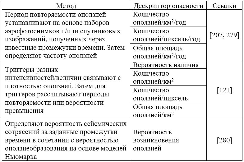
Избранные работы по вышеупомянутым подходам к пространственно не приуроченному анализу оползневых опасностей приведены в таблице 12.
Таблица 12. Пространственно не приуроченная региональная оценка оползневой опасности
Пространственно приуроченный анализ опасности
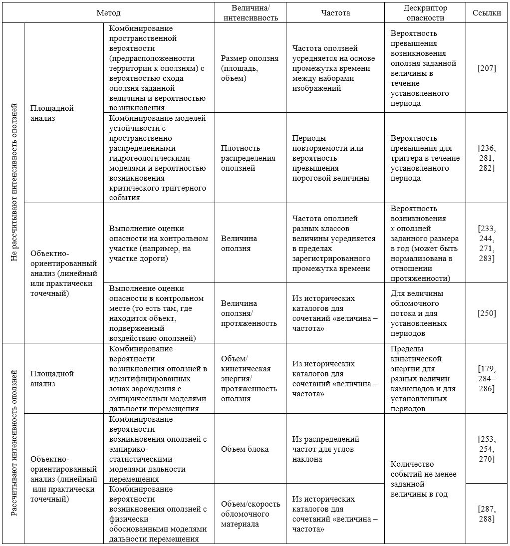
В локальном и детальном (сайт-специфическом) масштабах разрешение ЦМР обычно позволяет рассчитать вероятность возникновения оползня в каждом анализируемом элементе площади (например, в пикселе). Анализ может быть выполнен путем или включения, или исключения анализа дальности перемещения и последующего расчета интенсивности (таблица 13). Далее эти два варианта рассматриваются более подробно.
Таблица 13. Пространственно приуроченный анализ оползневой опасности
Оценка опасности без расчета интенсивности оползней
Этот тип анализа обычно проводится для географически ограниченных оползней (например, для медленно движущихся оползней с малой дальностью перемещения) со смещениями, которые не могут быть представлены за пределами анализируемой территориальной единицы (например, ячейки или пикселя). Он также выполняется для линейных или практически точечных объектов, расположенных далеко от зоны зарождения оползней, для которых оползневая опасность определяется на основе наблюдений за прошлыми событиями. В обоих случаях интенсивность не рассчитывается, а риск оценивается с учетом упрощающих допущений относительно уязвимости объектов, которые могут подвергнуться воздействию оползней. Рассмотрим эти случаи подробнее.
1. Анализ опасности схода географически ограниченных оползней. Для расчета вероятностей воздействия оползней на территориальные единицы (например, такие как пиксель, бассейн) при анализе или в региональных, или в локальных масштабах используются комбинации пространственно распределенных гидрогеологических моделей и моделей устойчивости, включающих как зону зарождения, так и зону аккумуляции оползневого материала. Опасность выражается как годовая вероятность либо разрушений склонов, либо реактивизации существующих оползней в каждой единице территории. Если более конкретно, то опасность рассчитывается как условная вероятность разрушения склона после триггерного события (например, критического количества дождевых осадков или землетрясения). Для каждой территориальной единицы вычисляется коэффициент устойчивости склона с использованием модели устойчивости бесконечного склона, в которой вероятность разрушения получается как годовая вероятность превышения критического количества дождевых осадков [221, 236, 281]. Для разрушений, вызванных землетрясениями, применяется обычный анализ сейсмической опасности с определением пиковых ускорений грунта (PGA – peak ground accelerations) для разных периодов повторяемости, а устойчивость склонов, подверженных воздействиям землетрясений с разными периодами повторяемости, исследуется с использованием псевдостатического анализа [74]. В качестве альтернативы вероятность оползневого события может быть рассчитана на основе наблюдаемой частоты прошлых оползней [289]. Пример этого привели авторы работы [207], которые определили геоморфогидрологические единицы и получили вероятность пространственно приуроченного возникновения оползней для каждой единицы территории с помощью дискриминантного анализа.
2. Анализ опасности, выполняемый для контрольного отрезка линейного объекта или для практически точечного объекта. Для анализа опасности, который фокусируется на определенных отрезках линейных объектов или на определенных местах, не требуется расчет дальности перемещения оползней. Этот анализ обычно выполняется для транспортных коридоров, для которых имеются зарегистрированые данные об оползневых событиях, а подверженные возможному воздействию оползней объекты (автомобили, люди) крайне уязвимы для событий низкой интенсивности. В таких случаях ни скорость, ни кинетическая энергия не вычисляются. Величина события используется для определения, например, количества затронутых полос или ширины оползневой массы, а также для расчета вероятности воздействия на уязвимые объекты [123, 233, 244, 271, 283]. Опасность может быть выражена либо в относительном виде (то есть как годовая вероятность схода оползней заданной величины на единицу длины), либо в абсолютном виде (то есть как количество оползневых событий в год).
Комбинированный анализ опасностей инициирования и дальности перемещения оползней
При комбинированном анализе опасностей инициирования и дальности перемещения учитывается пространственное распределение интенсивности оползня. При заданном объеме камнепада вдоль его пути будут изменяться скорость и кинетическая энергия (или энергия удара) [256]. Интенсивность камнепада зависит не только от его размера (величины), поскольку сходные значения кинетической энергии могут быть результатом разных сочетаний объемов и скоростей. Следовательно, картирование опасностей камнепадов должно выполняться с помощью моделей дальности перемещения, которые рассчитывают возможные пути камнепадов, расположение препятствий, которые могут останавливать падающие блоки, значения скорости и кинетической энергии камней, а также пространственное распределение кинетической энергии.
Критически важным вопросом является определение характерного объема камнепада. В случае камнепадов с фрагментацией отделившегося от склона материала [172] опасность возникает из-за отдельных камней, которые движутся по более или менее независимым траекториям. Однако зависимости «величина – частота», которые обычно определяются по данным инвентаризаций камнепадов, часто связывают частоту с объемом исходной отделившейся от склона массы, а не с размерами ее отдельных блоков, которые в конечном итоге достигают контрольного участка, а это может привести к завышению оценок энергии удара и к занижению вероятности удара по интересующему участку. К сожалению, в настоящее время в большинстве доступных программ не учитывается процесс фрагментации при камнепадах. Если при анализе дальности перемещения камнепадный процесс рассматривается как движение отдельного камня, то должны быть отражены наиболее вероятные будущие события. Репрезентативный размер блока может быть определен с использованием таких геометрических характеристик основных систем трещин в скальных породах, наблюдаемых на поверхности зоны зарождения, как длина трещин и расстояния между ними, и/или с применением распределения размеров фрагментов на склоне [254, 290].
Для обломочных потоков, как и для камнепадов, интенсивность напрямую не коррелирует с общим объемом движущегося обломочного материала. Разные обломочные потоки в каждом случае приводят к разным распределениям интенсивности и вероятности воздействия на контрольный участок в зависимости от динамики перемещения. Поэтому согласно работе [206] карта интенсивности опасности должна отражать набор пар значений интенсивности и вероятности воздействия для разных типов обломочных потоков и классов их величин. Для оценки опасности обломочных потоков в детальном (сайт-специфическом) масштабе обычно применяются два разных подхода:
1) оценивается вероятность того, что определенный объем обломочного материала приведет к образованию обломочного потока, и используется физически обоснованная (2D или 3D) модель дальности перемещения для определения зоны воздействия и параметров интенсивности [287, 288];
2) оцениваются вероятности перемещения обломочных потоков разной величины через контрольные участки (и конусы выноса) ниже зоны их зарождения с использованием зависимостей «величина – частота» [250].
Используя разные вероятности, можно затем составить карты опасностей для обломочных потоков для конкретных периодов повторяемости (например, 100, 500 и, возможно, 2 500 лет).
Перевод статьи выполнен при поддержке ГК «ПЕТРОМОДЕЛИНГ» и Алексея Бершова.
-
Продолжение раздела по оценке оползневой опасности и остальной части статьи следует.
ИСТОЧНИК ДЛЯ ПЕРЕВОДА
Corominas J., Van Westen C., Frattini P., Cascini L., Malet J.-P., Fotopoulou S., Catani F., Van Den Eeckhaut M., Mavrouli O., Agliardi F., Pitilakis K., Winter M.G., Pastor M., Ferlisi S., Tofani V., Hervas J., Smith J.T. Recommendations for the quantitative analysis of landslide risk // Bulletin of Engineering Geology and the Environment. 2014. Vol. 73. № 2. P. 209–263. DOI:10.1007/s10064-013-0538-8. URL: https://www.researchgate.net/publication/259032330_Recommendations_for_the_quantitative_analysis_of_landslide_risk.
СПИСОК ЛИТЕРАТУРЫ, ИСПОЛЬЗОВАННОЙ АВТОРАМИ ПЕРЕВЕДЕННОЙ СТАТЬИ
- Fell R., Corominas J., Bonnard Ch., Cascini L., Leroi E., Savage W.Z. Guidelines for landslide susceptibility, hazard and risk zoning for land use planning (on behalf of the JTC-1 Joint Technical Committee on Landslides and Engineered Slopes) // Eng. Geol. 2008. Vol. 102. P. 85–98.
- TC32 – Technical Committee 32 (Engineering Practice of Risk Assessment and Management) of the International Society of Soil Mechanics and Geotechnical Engineering (ISSMGE). Risk assessment – glossary of terms. 2004. URL: http://www.engmath.dal.ca/tc32/2004Glossary_Draft1.pdf.
- Terminology of disaster risk reduction. Geneva: United Nations International Strategy for Disaster Reduction (UN-ISDR). 2004. URL: http://www.unisdr.org/eng/library/lib-terminology-eng%20home.htm.
- Cruden D.M., Varnes D.J. Landslide types and processes // Landslides – investigation and mitigation: Transportation Research Board Special Report № 247 (ed. by A.T. Turner, R.L. Schuster). Washington, DC: National Academy Press, 1996. P. 36–75.
- Hungr O., Evans S.G., Bovis M.J., Hutchinson J.N. A review of the classification of landslides of the flow type // Environ. Eng. Geosci. 2001. Vol. VII. № 3. P. 221–238.
- Hungr O., Leroueil S., Picarelli L. Varnes classification of landslide types, an update // Eberhardt E., Froesse C., Turner A.K., Leroueil S. (eds.). Landslides and engineered slopes: protecting society through improved understanding. Boca Raton: CRC Press, 2012. Vol. 1. P. 47–58.
- IAEG Commission on Landslides. Suggested nomenclature for landslides // Bull. Int. Assoc. Eng. Geol. 1990. Vol. 41. P. 13–16.
- Petley D.N. Landslides and engineered slopes: protecting society through improved understanding // Eberhardt E., Froese C., Turner A.K., Leroueil S. (eds.). Landslides and engineered slopes. London: CRC, 2012. Vol. 1. P. 3–13.
- OFAT, OFEE, OFEFP. Recommandations 1997: prise en compte des dangers dus aux mouvements de terrain dans le cadre des activites de l’amenagement du territoire. Berne: OCFIM, 1997. 42 p.
- Assessment of landslide risk in natural hillsides in Hong Kong: Report № 191. Hong Kong: Hong Kong Geotechnical Engineering Office (GEO), 2006. 117 p.
- Guidelines for landslide susceptibility, hazard and risk zoning for land use management // Aust. Geomech. Australian Geomechanics Society (AGS) Landslide Taskforce Landslide Zoning Working Group, 2007. Vol. 42. № 1. P. 13–36.
- Fell R., Corominas J., Bonnard Ch., Cascini L., Leroi E., Savage W.Z. Guidelines for landslide susceptibility, hazard and risk zoning for land-use planning (on behalf of the JTC-1 Joint Technical Committee on Landslides and Engineered Slopes) // Comment. Eng. Geol. 2008. Vol. 102. P. 99–111.
- Corominas J. et al. (eds.) SafeLand Deliverable D2.1: overview of landslide hazard and risk assessment practices. 2010. URL: http://www.safeland-fp7.eu/.
- Lee E.M., Jones D.K.C. Landslide risk assessment. London: Thomas Telford, 2004. 454 p.
- Glade T., Anderson M., Crozier M.J. Landslide hazard and risk. Chichester: Wiley, 2005. 802 p.
- Smith K., Petley D.N. Environmental hazards: assessing risk and reducing disaster. London: Taylor & Francis, 2008.
- Van Westen C.J., Van Asch T.W.J., Soeters R. Landslide hazard and risk zonation: why is it still so difficult? // Bull. Eng. Geol. Environ. 2005. Vol. 65. P. 167–184.
- IUGS Working Group on Landslides, Committee on Risk Assessment. Quantitative risk assessment for slopes and landslides – the state of the art // Cruden D., Fell R. (eds.). Landslide risk assessment. Amsterdam: A.A. Balkema, 1997. P. 3–12.
- Brabb E.E., Pampeyan E.H., Bonilla M.G. Landslide susceptibility in San Mateo County, California // Misc. Field Studies, map MF-360 (scale 1:62500). Reston: US Geological Survey, 1972.
- Humbert M. Les mouvements de terrains // Principes de realisation d’une carte previsionnelle dans les Alpes // Bull. du BRGM. Sect. III. 1972. Vol. 1. P. 13–28.
- Kienholz H. Map of geomorphology and natural hazards of Grindelwald, Switzerland, scale 1:10000 // Artic Alp. Res. 1978. Vol. 10. P. 169–184.
- Brand E.W. Special lecture: landslide risk assessment in Hong Kong // Proceedings of the V International Symposium on Landslides, Lausanne, Switzerland. Amsterdam: A.A. Balkema, 1988. Vol. 2. P. 1059–1074.
- Wong H.N., Chen Y.M., Lam K.C. Factual report on the November 1993 natural terrain landslides in three study areas on Lantau Island: GEO Report № 61. Hong Kong: Geotechnical Engineering Office (GEO), 1997. 42 p.
- Hardingham A.D., Ho K.K.S., Smallwood A.R.H., Ditchfield C.S. Quantitative risk assessment of landslides – a case history from Hong Kong // Proceedings of the seminar on geotechnical risk management. Geotechnical Division, Hong Kong, 1998. Hong Kong: Hong Kong Institution of Engineers, 1998. P. 145–152.
- Wong H.N., Ho K.K.S. Overview of risk of old man-made slopes and retaining walls in Hong Kong // Proceedings of the Seminar on Slope Engineering in Hong Kong, Hong Kong, 1998. Hong Kong: A.A. Balkema, 1998. P. 193–200.
- Ho K.K.S,, Leroi E., Roberds B. Quantitative risk assessment – application, myths and future direction // Proceedings of the International Conference on Geotechnical and Geological Engineering (GeoEng2000), Melbourne, Australia, 9–24 November 2000. Vol. 1. P. 269–312.
- Wong H.N. Landslide risk assessment for individual facilities – state of the art report // Hungr O., Fell R., Couture R., Eberhardt E. (eds.) Proceedings of the International Conference on Landslide Risk Management. London: Taylor & Francis, 2005. P. 237–296.
- Landslide risk management concepts and guidelines // Aust. Geomech. Australian Geomechanics Society (AGS), 2000. Vol. 35. № 1. P. 49–92.
- Cascini L. Applicability of landslide susceptibility and hazard zoning at different scales // Eng, Geol, 2008. Vol. 102. P. 164–177.
- Cascini L., Bonnard Ch., Corominas J., Jibson R., Montero-Olarte J. Landslide hazard and risk zoning for urban planning and development – state of the art report // Hungr O., Fell R., Couture R., Eberhardt E. (eds.). Landslide risk management. Amsterdam: A.A. Balkema, 2005. P. 199–235.
- Nadim F., Kjeksta O. Assessment of global high-risk landslide disaster hotspots // Sassa K., Canuti P. (eds.). Landslides – disaster risk reduction. Berlin: Springer, 2009. P. 213–221.
- Nadim F., Kjekstad O., Peduzzi P., Herold C., Jaedicke C. Global landslide and avalanche hotspots // Landslides. 2006. Vol. 3. № 2. P. 159–174.
- Fell R., Ho K.K.S., Lacasse S., Leroi E. A framework for landslide risk assessment and management // Hungr O., Fell R., Couture R., Eberhardt E. (eds.). Landslide risk management. London: Taylor and Francis, 2005. P. 3–26.
- Soeters R., Van Westen C.J. Slope instability recognition, analysis and zonation // Turner A.K., Schuster R.L. (eds.). Landslides investigation and mitigation: TRB Special Report 247. Washington, DC: National Academy Press, 1996. P. 129–177.
- Leroi E., Bonnard Ch., Fell R., McInnes R. Risk assessment and management – state of the art report // Hungr O., Fell R., Couture R., Eberhardt E. (eds.). Landslide risk management. Amsterdam: A.A. Balkema, 2005. P. 159–198.
- Van Westen C.J., Castellanos Abella E.A., Sekha L.K. Spatial data for landslide susceptibility, hazards and vulnerability assessment: an overview// Eng. Geol. 2008. Vol. 102. № 3–4. P. 112–131.
- Crosta G.B., Agliardi F., Frattini P., Sosoi R. (eds.). SafeLand Deliverable 1.1: landslide triggering mechanisms in Europe – overview and state of the art. Identification of mechanisms and triggers. 2012. URL: http://www.safeland-fp7.eu/.
- Glade T., Crozier M.J. A review of scale dependency in landslide hazard and risk analysis // Glade T., Anderson M., Crozier M.J. (eds.). Landslide hazard and risk. London: Wiley, 2005. P. 75–138.
- Turner A.K., Schuster L.R. (eds.). Landslides, investigation and mitigation: Transportation Research Board Special Report 247. Washington, DC: National Research Council, National Academy Press, 1996. 673 p.
- Springman S., Seward L., Casini F., Askerinejad A., Malet J.-P., Spickerman A., Travelletti J. (eds.). SafeLand Deliverable D1.3: analysis of the results of laboratory experiments and of monitoring in test sites for assessment of the slope response to precipitation and validation of prediction models. 2011. URL: http://www.safeland-fp7.eu/.
- Jongmans D., Garambois S. Geophysical investigation of landslides: a review // Bull. Soc. Geol. France. 2007. Vol. 178. P. 101–112.
- Corominas J., Moya J. A review of assessing landslide frequency for hazard zoning purposes // Eng. Geol. 2008. Vol. 102. P. 193–213.
- Cepeda J., Colonnelli S., Meyer N.K., Kronholm K. SafeLand Deliverable D1.5: statistical and empirical models for prediction of precipitation-induced landslides. 2012. URL: http://www. safeland-fp7.eu/.
- Pitilakis K., Fotopoulou S. et al. (eds.). SafeLand Deliverable D2.5: physical vulnerability of elements at risk to landslides: methodology for evaluation, fragility curves and damage states for buildings and lifelines. 2011. URL: http://www.safeland-fp7.eu/.
- Metternicht G., Hurni L., Gogu R. Remote sensing of landslides: an analysis of the potential contribution to geo-spatial systems for hazard assessment in mountainous environments // Remote Sens. Environ. 2005. Vol. 98. № 23. P. 284–303.
- Singhroy V. Remote sensing of landslides // Glade T., Anderson M., Crozier M.J. (eds.). Landslide hazard and risk. Chichester: Wiley, 2005. P. 469–492.
- Kaab A. Photogrammetry for early recognition of high mountain hazards: new techniques and applications // Phys. Chem. Earth. Part B. 2010. Vol. 25. № 9. P. 765–770.
- Michoud C., Abellan A., Derron M.H., Jaboyedoff M. (eds.). SafeLand Deliverable D4.1: review of techniques for landslide detection, fast characterization, rapid mapping and long-term monitoring. 2010. URL: Available at http://www.safeland-fp7.eu/.
- Stumpf A., Malet J.-P. Kerle N. SafeLand Deliverable D4.3: creation and updating of landslide inventory maps, landslide deformation maps and hazard maps as inputs for QRA using remote-sensing technology. 2011. URL: http://www.safeland- fp7.eu/.
- WP/WLI. A suggested method for describing the activity of a landslide // Bull. Int. Assoc. Eng. Geol. 1993. Vol. 47. P. 53–57.
- Guzzetti F., Mondini A.S., Cardinali M., Fiorucci F., Santangelo M., Chan K.T. Landslide inventory maps: new tools for an old problem // Earth. Sci. Rev. 2012. Vol. 112. P. 42–66.
- Cardinali M. A geomorphological approach to the estimation of landslide hazards and risk in Umbria, Central Italy // Nat. Hazards Earth. Syst. Sci. 2002. Vol. 2. P. 57–72.
- Haugerud R.A., Harding D.J., Johnson S.Y., Harless J.L., Weaver C.S., Sherrod B.L. High-resolution LiDAR topography of the Puget Lowland. Washington – a bonanza for earth science // GSA Today. 2003. Vol. 13. P. 4–10.
- Ardizzone F., Cardinali M., Galli M., Guzzetti F., Reichenbach P. Identification and mapping of recent rainfall-induced landslides using elevation data collected by airborne Lidar // Nat. Hazards Earth. Syst. Sci. 2007. Vol. 7. P. 637–650.
- Van Den Eeckhaut M., Reichenbach P., Guzzetti F., Rossi M., Poesen J. Combined landslide inventory and susceptibility assessment based on different mapping units: an example from the Flemish Ardennes, Belgium // Nat. Hazards Earth. Syst. Sci. 2009. Vol. 9. № 2. P. 507–521.
- Razak K.A., Straatsma M.W., van Westen C.J., Malet J.-P., de Jong S.M. Airborne laser scanning of forested landslides characterization: terrain model quality and visualization // Geomorphology. 2011. Vol. 126. P. 186–200.
- Hervas J., Barredo J.I., Rosin P.L., Pasuto A., Mantovani F., Silvano S. Monitoring landslides from optical remotely sensed imagery: the case history of Tessina landslide, Italy // Geomorphology. 2003. Vol. 54. P. 63–75.
- Borghuis A.M., Chang K., Lee H.Y. Comparison between automated and manual mapping of typhoon-triggered landslides from SPOT-5 imagery // Int. J. Remote. Sens. 2007. Vol. 28. P. 1843–1856.
- Mondini A.C., Guzzetti F., Reichenbach P., Rossi M., Cardinali M., Ardizzone M. Semiautomatic recognition and mapping of rainfall induced shallow landslides using optical satellite images // Remote Sens. Environ. 2011. Vol. 115 . № 7 . P. 1743–1757.
- Martha T.R., Kerle N., Jetten V., van Westen C.J., Kumar K.V. Characterising spectral, spatial and morphometric properties of landslides for semi-automatic detection using object-oriented methods // Geomorphology. 2010. Vol. 116. № 1–2. P. 24–36.
- Lu P., Stumpf A., Kerle N., Casagli N. Object-oriented change detection for landslide rapid mapping // IEEE Geosci. Remote Sens. Lett. 2011. Vol. 99. P. 701–705.
- Travelletti J., Malet J.-P., Schmittbuhl J., Toussaint R., Delacourt C., Stumpf A. A multi-temporal image correlation method to characterize landslide displacements // Ber. Geol. B.-A. 2010. Vol. 82. P. 50–57.
- Niethammer U., James M.R., Rothmund S., Travelletti J., Joswig M. UAV-based remote sensing of the Super-Sauze landslide: evaluation and results // Eng. Geol. 2012. Vol. 128. P. 2–11. DOI: 10.1016/j.enggeo.2011.03.012.
- Martha T.R., Kerle N., Jetten V., van Westen C.J., Vinod Kumar K. Landslide volumetric analysis using Cartosat-1-derived DEMs // Geosci. Remote Sens. Lett. IEEE, 2010. Vol. 7. № 3. P. 582–586.
- Jaboyedoff M., Oppikofer T., Abellan A., Derron M.-H., Loye A., Metzger R., Pedrazzini A. Use of LIDAR in landslide investigations: a review // Nat. Hazards. 2012. Vol. 61. № 1. P. 5–28.
- Ferretti A., Prati C., Rocca F. Permanent scatterers in SAR interferometry // Trans. Geosci. Remote Sens. IEEE, 2001. Vol. 39. № 1. P. 8–20.
- Berardino P., Fornaro G., Lanari R., Sansosti E. A new algorithm for surface deformation monitoring based on small baseline differential interferograms // Trans. Geosci. Remote Sens. IEEE, 2002. Vol. 40. № 11. P. 2375–2383.
- Farina P., Colombo D., Fumagalli A., Marks F., Moretti S. Permanent scatters for landslide investigations: outcomes from the ESA-SLAM project // Eng. Geol. 2006. Vol. 88. P. 200–217.
- Farr T.G., Rosen P.A., Caro E., Crippen R., Duren R., Hensley S., Kobrick M., Paller M., Rodriguez E., Roth L., Seal D., Shaffer S., Shimada J., Umland J., Werner M., Oskin M., Burbank D., Alsdorf D. The Shuttle Radar Topography Mission // Rev. Geophys. 2007. Vol. 45. Issue RG2004. DOI:101029/2005RG000183.
- METI/NASA. ASTER Global Digital Elevation Model. Tokyo, Washington, DC: Ministry of Economy, Trade and Industry of Japan (METI), National Aeronautics and Space Administration (NASA), 2009. URL: http://asterweb.jpl.nasa.gov/gdem.asp; http://www.gdem.ersdac.jspacesystems.or.jp.
- Nelson A., Reute H.I., Gessler P. Chapter 3: DEM production methods and sources // Hengl T., Reute H.I. (eds.) Developments in soil science, vol. 33. Amsterdam: Elsevier, 2009. P. 65–85.
- Smith M.J., Pain C.F. Applications of remote sensing in geomorphology // Prog. Phys. Geogr. 2009. Vol. 33. № 4. P. 568–582.
- Aleotti P., Chowdhury R. Landslide hazard assessment: summary review and new perspectives // Bull. Eng. Geol. Environ. 1999. Vol. 58. P. 21–44.
- Dai F.C., Lee C.F., Ngai Y.Y. Landslide risk assessment and management: an overview // Eng. Geol. 2002 . Vol. 64. P. 65–87.
- Chacon J., Irigaray C., Fernandez T., El Hamdouni R. Engineering geology maps: landslides and geographical information systems // Bull. Eng. Geol. Environ. 2006. Vol. 65. P. 341–411.
- Dobbs M.R., Culshaw M.G., Northmore K.J., Reeves H.J., Entwisle D.C. Methodology for creating national engineering geological maps of the UK // Q. J. Eng. Geol. Hydrogeol. 2012 . Vol. 45. № 3. P. 335–347.
- Xie M, Tetsuro E, Zhou G., Mitani Y. Geographic Information Systems-based three-dimensional critical slope stability analysis and landslide hazard assessment // J. Geotech Geoenviron. Eng. 2003. Vol. 129. № 12. P. 1109–1118.
- Culshaw M.G. From concept towards reality: developing the attributed 3D geological model of the shallow subsurface // Q. J. Eng. Geol. Hydrogeol. 2005. Vol. 38. P. 231–284.
- Ghosh S., Gunther A., Carranza E.J.M., van Westen C.J., Jetten V.G. Rock slope instability assessment using spatially distributed structural orientation data in Darjeeling Himalaya (India) // Earth Surf. Proc. Land. 2010. Vol. 35. № 15. P. 1773–1792.
- Guimaraes R.F., Montgomery D.R., Greenberg H.M., Fernandes N.F., Trancoso Gomes R.A., de Carvalho J., Osmar A. Parameterization of soil properties for a model of topographic controls on shallow landsliding: application to Rio de Janeiro // Eng. Geol. 2003. Vol. 69. № 1–2. P. 99–108.
- Bakker M.M., Govers G., Kosmas C., Vanacker V., van Oost K., Rounsevell M. Soil erosion as a driver of land-use change // Agric. Ecosyst. Environ. 2005. Vol. 105. № 3. P. 467–481.
- Bathurst J.C., Moretti G., El-Hames A., Begueria S., Garcia-Ruiz J.M. Modelling the impact of forest loss on shallow landslide sediment yield, Ijuez river catchment, Spanish Pyrenees // Hydrol. Earth. Syst. Sci. 2007 . Vol. 11. № 1. P. 569–583.
- Talebi A., Troch P.A., Uijlenhoet R. A steady-state analytical slope stability model for complex hillslopes // Hydrol. Process. 2008. Vol. 22. № 4. P. 546–553.
- Montgomery D.R., Dietrich W.E. A physically based model for the topographic control on shallow landsliding // Water Resour .Res. 1994. Vol. 30. № 4. P. 1153–1171.
- Santacana N., Baeza B., Corominas J., De Paz A., Marturia J. A GIS-based multivariate statistical analysis for shallow landslide susceptibility mapping in La Pobla de Lillet area (Eastern Pyrenees, Spain) // Nat. Hazards. 2003. Vol. 30. P. 281–295.
- Dietrich W.E., Reiss R., Hsu M.L., Montgomery D.R. A process-based model for colluvial soil depth and shallow landsliding using digital elevation data // Hydrol. Process. 1995. Vol. 9. P. 383–400.
- D’Odorico P. A possible bistable evolution of soil thickness //. J. Geophys. Res. 2000. Vol. 105. № B11. P. 25927–25935.
- Tsai C.C., Chen Z.S., Duh C.T., Horng F.W. Prediction of soil depth using a soil-landscape regression model: a case study on forest soils in southern Taiwan // Natl. Sci. Counc. Repub. China. Part B. Life. Sci. 2001. Vol. 25. № 1. P. 34–39.
- Van Beek L.H. Assessment of the influence of changes in landuse and climate on landslide activity in a Mediterranean environment: Ph.D. thesis. Utrecht: University of Utrecht, 2002. 363 p.
- Penizek V., Boruvka L. Soil depth prediction supported by primary terrain attributes: a comparison of methods // Plant. Soil Environ. 2006. Vol. 52. № 9. P. 424–430.
- Catani F., Segoni S., Falorni G. Accurate basin scale soil depth modelling and its impact on shallow landslides prediction. European Geosciences Union General Assembly 2007, Vienna, Austria // Geophys. Res. Abstr. 2007. Vol. 9. P. 10828.
- Hengl T., Heuvelink G.B.M., Stein A. A generic framework for spatial prediction of soil variables based on regression-kriging // Geoderma. 2004. Vol. 120. № 1–2. P. 75–93.
- Kuriakose S.L., Devkota S., Rossiter D.G., Jetten V.J. Prediction of soil depth using environmental variables in an anthropogenic landscape, a case study in the Western Ghats of Kerala, India // Catena. 2009. Vol. 79. № 1. P. 27–38.
- Gustavsson M., Kolstrup E., Seijmonsbergen A.C. A new symbol-and-GIS-based detailed geomorphological mapping system: renewal of a scientific discipline for understanding landscape development // Geomorphology. 2006. Vol. 77. № 1-2. P. 90–111.
- Pike R.J. Geomorphometry – diversity in quantitative surface analysis // Prog. Phys. Geogr. 2000. Vol. 24 . № 1. P. 1–20.
- Asselen S.V., Seijmonsbergen A.C. Expert-driven semi-automated geomorphological mapping for a mountainous area using a laser DTM // Geomorphology. 2006. Vol. 78. № 3–4. P. 309–320.
- Matthews J.A., Brunsden D., Frenzel B, Glaser B., Weiss M.M. (eds.) Rapid mass movement as a source of climatic evidence for the Holocene // Palaeoclimate Res. 1997 . Vol. 19. 444 p.
- Van Beek L.P.H., Van Asch T.W.J. Regional assessment of the effects of land-use change and landslide hazard by means of physically based modelling // Nat. Hazards. 2004. Vol. 30. № 3. P. 289–304.
- Glade T. Landslide occurrence as a response to land use change: a review of evidence from New Zealand // Catena. 2003. Vol. 51. № 3–4. P. 297–314.
- Kuriakose S.L. Physically-based dynamic modelling of the effect of land use changes on shallow landslide initiation in the Western Ghats of Kerala, India: Ph.D. thesis. Utrecht: University of Utrecht, 2010. ISBN 978-90-6164-298-5.
- Crosta G.B., Frattini P. Distributed modelling of shallow landslides triggered by intense rainfall // Nat. Hazards Earth Syst. Sci. 2003. Vol. 3. № 1–2. P. 81–93.
- Collison A., Wade J., Griths S., Dehn M. Modelling the impact of predicted climate change on landslide frequency and magnitude in SE England // Eng. Geol. 2000. Vol. 55. P. 205–218.
- Melchiorre C., Frattini P. Modelling probability of rainfall-induced shallow landslides in a changing climate, Otta, Central Norway // Clim. Chang. 2012. Vol. 113. № 2. P. 413–436.
- Comegna L., Picarelli L., Bucchignani E., Mercogliano P. Potential effects of incoming climate changes on the behaviour of slow active landslides in clay // Landslides. 2012. Vol. 10. № 4. P. 373–391. DOI:101007/s10346-012-0339-3.
- Keefer D.K. Investigating landslides caused by earthquakes – a historical review // Surv. Geophys. 2002. Vol. 23. P. 473–510.
- Meunier P., Hovius N., Haines A.J. Regional patterns of earthquake-triggered landslides and their relation to ground motion // Geophys. Res. Lett. 2007. Vol. 34. № 20. Paper L20408.
- Gorum T., Fan X., van Westen C.J., Huang R.Q., Xu Q., Tang C., Wang G. Distribution pattern of earthquake-induced landslides triggered by the 12 May 2008 Wenchuan earthquake // Geomorphology. 2011 . Vol. 133. № 3–4. P. 152–167.
- Miles S.B., Keefer D.K. Evaluation of CAMEL – comprehensive areal model of earthquake-induced landslides // Eng. Geol. 2009. Vol. 104. P. 1–15.
- Alexander E.D. Vulnerability to landslides // Landslide risk assessment (ed. by T. Glade, M.G. Anderson, M.J. Crozier). London: Wiley, 2005. P. 175–198.
- Brenner C. Building reconstruction from images and laser scanning // Int. J. Appl. Earth Obs. Geoinf. 2005. Vol. 6. № 3–4. P. 187–198.
- Chen K., McAneney J., Blong R., Leigh R., Hunter L., Magill C. Defining area at risk and its effect in catastrophe loss estimation: a dasymetric mapping approach // Appl. Geogr. 2004. Vol. 24 . P. 97–117.
- Heuvelink G.B.M. Error propagation in environmental modelling with GIS. London: Taylor & Francis, 1998. 150 p.
- Fisher P.F., Tate N.J. Causes and consequences of error in digital elevation models // Prog. Phys. Geogr. 2006. Vol. 30. P. 467–489.
- Wechsler S.P. Uncertainties associated with digital elevation models for hydrologic applications: a review // Hydrol. Earth Syst. Sci. 2007. Vol. 11. P. 1481–1500.
- Ardizzone F., Cardinali M., Carrara A., Guzzetti F., Reichenbach P. Impact of mapping errors on the reliability of landslide hazard maps // Nat. Hazards Earth Syst. Sci. 2002. Vol. 2. P. 3–14.
- Van Den Eeckhaut M., Hervas J. State of the art of national landslide databases in Europe and their potential for assessing landslide susceptibility, hazard and risk // Geomorphology. 2012. Vol. 139-140. P. 545–558.
- Carrara A., Guzzetti F., Cardinali M., Reichenbach P. Use of GIS technology in the prediction and monitoring of landslide hazard // Nat. Hazards. 1999. Vol. 20. № 2–3. P. 117–135.
- Guzzetti F., Carrara A., Cardinali M., Reichenbach P. Landslide hazard evaluation: a review of current techniques and their application in a multi-scale study // Central Italy Geomorphol. 1999. Vol. 31. № 1–4. P. 181 –216.
- Wieczorek G.F. Preparing a detailed landslide-inventory map for hazard evaluation and reduction // Bull. Assoc. Eng. Geol. 1984. Vol. 21. № 3. P. 337–342.
- Crozier M.J. Multiple occurrence regional landslide events in New Zealand: hazard management issues // Landslides. 2005. Vol. 2. P. 247–256.
- Reid L.M., Page M.J. Magnitude and frequency of landsliding in a large New Zealand catchment // Geomorphology. 2003. Vol. 49. P. 71–88.
- Guzzetti F., Cardinali M., Reichenbach P., Carrara A. Comparing landslide maps: a case study in the upper Tiber River Basin, central Italy // Environ. Manage. 2000. Vol. 25. № 3. P. 247–363.
- Jaiswal P., van Westen C.J. Estimating temporal probability for landslide initiation along transportation routes based on rainfall thresholds // Geomorphology. 2009. Vol. 112. P. 96–105.
- Squarzoni C., Delacourt C., Allemand P. Nine years of spatial and temporal evolution of the La Vallette landslide observed by SAR interferometry // Eng. Geol. 2003. Vol. 68. P. 53–66.
- Colesanti C., Wasowski J. Investigating landslides with space-borne Synthetic Aperture Radar (SAR) interferometry // Eng. Geol. 2006. Vol. 88. P. 173–199.
- Coe J.A., Michael J.A., Crovelli R.A., Savage W.A. Preliminary map showing landslides densities, mean recurrence intervals, and exceedance probabilities as determined from historic records: open-file report 00-303. Seattle: USGS, 2000.
- Bulut F., Boynukalin S., Tarhan F., Ataoglu E. Reliability of isopleth maps // Bull. Eng. Geol. Environ. 2000. Vol. 58 . P. 95–98.
- Valadao P., Gaspar J.L., Queiroz G., Ferreira T. Landslides density map of S. Miguel Island, Azores Archipelago // Nat. Hazards Earth Syst. Sci. 2002. Vol. 2. P. 51–56.
- Lee S. Application of logistic regression model and its validation for landslide susceptibility mapping using GIS and remote sensing data // Int. J. Remote Sens. 2005. Vol. 26. № 7. P. 1477–1491.
- Yin K.J., Yan T.Z. Statistical prediction model for slope instability of metamorphosed rocks // Proc. 5th Int. Symp. on Landslides, Lausanne, Switzerland, 10–15 July 1988. Vol. 2. P. 1269–1272.
- Van Westen C.J. Application of geographic information systems to landslide hazard zonation: Ph.D. dissertation, ITC publ. № 15. Enschede: ITC, 1993. 245 p.
- Bonham-Carter G.F. Geographic information system for geoscientists: modelling with GIS. Oxford: Pergamon, 1994. 398 p.
- Suzen M.L., Doyuran V. Data driven bivariate landslide susceptibility assessment using geographical information systems: a method and application to Asarsuyu catchment // Turk. Eng. Geol. 2004. Vol. 71. P. 303–321.
- Chung C.F., Fabbri A.G. Representation of geoscience data for information integration // J. Non-Renew. Resour. 1993. Vol. 2. № 2. P. 122–139.
- Luzi L. Application of favourability modelling to zoning of landslide hazard in the Fabriano Area, Central Italy // Proc. First Joint Eur. Conf. & Exhibition on Geographical Information, The Hague, Netherlands, 26–31 March 1995. P. 398–402.
- Carrara A. Multivariate models for landslide hazard evolution // Math. Geol. 1983. Vol. 15. P. 403–427.
- Gorsevski P.V., Gessler P., Foltz R.B. Spatial prediction of landslide hazard using discriminant analysis and GIS // GIS in the Rockies 2000: Conference and Workshop: Applications for the 21st Century, Denver, CO, USA, 25–27 September 2000. URL; https://studylib.net/doc/12343493/gis-in-the-rockies-2000-conference-and-workshop.
- Ohlmacher G.C., Davis J.C. Using multiple logistic regression and GIS technology to predict landslide hazard in northeast Kansas // USA Eng. Geol. 2003. Vol. 69. № 33 . P. 331–343.
- Gorsevski P.V., Gessler P.E., Foltz R.B., Elliot W.J. Spatial prediction of landslide hazard using logistic regression and ROC analysis // Trans. GIS. 2006. Vol. 10. № 3. P. 395–415.
- Lee S., Ryu J.-H., Won J.-S., Park H.-J. Determination and application of the weights for landslide susceptibility mapping using an artificial neural network // Eng. Geol. 2004. Vol. 71 . № 3–4. P. 289–302.
- Ermini L., Catani F., Casagli N. Artificial neural networks applied to landslide susceptibility assessment // Geomorphology. 2005. Vol. 66. P. 327–343.
- Kanungo D.P., Arora M.K., Sarkar S., Gupta R.P. A comparative study of conventional, ANN black box, fuzzy and combined neural and fuzzy weighting procedures for landslide susceptibility zonation in Darjeeling Himalayas // Eng. Geol. 2006. Vol. 85. № 3–4 . P. 347–366.
- Pack R.T., Tarboton D.G., Goodwin C.N. The SINMAP approach to terrain stability mapping // 8th Congr. Int. Assoc. Eng. Geol., Vancouver, Canada, 21–25 September 1998.
- Baum R.L., Savage W.Z., Godt J.W. TRIGRS - a FORTRAN program for transient rainfall infiltration and grid-based regional slope stability analysis: US Geological Survey Open-File Report 02-0424. 2002. URL: http://pubs.usgs.gov/of/2002/ofr-02-424/.
- Casadei M., Dietrich W.E., Mille N.L. Testing a model for predicting the timing and location of shallow landslide initiation on soil mantled landscapes // Earth Surf. Proc. Land. 2003. Vol. 28. № 9. P. 925–950.
- Simoni S., Zanotti F., Bertoldi G., Rigon R. Modelling the probability of occurrence of shallow landslides and channelized debris flows using GEOtop-FS // Hydrol. Process. 2008. Vol. 22. P. 532–545.
- Jibson R.W., Harp E.L., Michael J.A. A method for producing digital probabilistic seismic landslide hazard maps: an example from the Los Angeles, California, area: open file report. Reston, USA: US Geological Survey, 1998. P. 98–113.
- Wang K.L., Lin M.I. Development of shallow seismic landslide potential map based on Newmark’s displacement: the case study of Chi-Chi earthquake, Taiwan // Environ. Earth Sci. 2010. Vol. 60. P. 775–785.
- Gunther A. SLOPEMAP: programs for automated mapping of geometrical and kinematical properties of hard rock hill slopes // Comput. Geosci. 2003. Vol. 29. P. 865–875.
- GEO-SLOPE. SLOPE/W. Calgary, Canada: GEO-SLOPE International, 2011. URL: http://www.geo-slope.com.
- Hungr O. A model for the run out analysis of rapid flow slides, debris flows and avalanches // Can. Geotech. J. 1995. Vol. 32. P. 610–623.
- Gitirana Jr.G., Santos M., Fredlund M. Three-dimensional slope stability model using finite element stress analysis // GeoCongress 2008, NewOrleans, LA, USA, 9–12 March 2008. P. 191–198.
- Hoek E., Grabinsky M.W., Diederichs M.S. Numerical modelling for underground excavations // Trans. Inst. Min. Metall. Sect. A. 1993. Vol. 100. P. A22–A30.
- Stead D., Eberhardt E., Coggan J., Benko B. Advanced numerical techniques in rock slope stability analysis: applications and limitations // LANDSLIDES – Causes, Impacts and Countermeasures, Davos, Switzerland, 17–21 June 2001. P. 615–624.
- Hart R.D. An introduction to distinct element modelling for rock engineering // Hudson J.A. (ed). Comprehensive rock engineering. Oxford: Pergamon, 1993.
- Horton P., Jaboyedoff M., Bardou E. Debris flow susceptibility mapping at a regional scale // Proceedings of the 4th Canadian Conference on Geohazards: From Causes to Management. Quebec, Canada: Presse de l’Universite Laval, 2008. P. 399–406.
- Hungr O., Corominas J., Eberhardt E. Estimating landslide motion mechanism, travel distance and velocity: state of the art report // Hungr O., Fell R., Couture R., Eberhardt E. (eds.). Landslide risk management. Amsterdam: A.A. Balkema, 2005. P. 99–128.
- Hoblitt R.P., Walder J.S., Driedger C.L., Scott K.M., Pringle P.T., Vallance J.W. Volcano hazards from Mount Rainier, Washington: revised open-file report 98-428. Reston: USGS, 1998.
- Corominas J., Copons R., Vilaplana J.M., Altimir J., Amigo J. Integrated landslide susceptibility analysis and hazard assessment in the principality of Andorra // Nat Hazards. 2003. Vol. 30 . P. 421–435.
- Ayala F.J., Cubillo S., Alvarez A., Dominguez M.J., Lain L., Lain R., Ortiz G. Large scale rockfall reach susceptibility maps in La Cabrera Sierra (Madrid) performed with GIS and dynamic analysis at 1:5000 // Nat Hazards. 2003. Vol. 30. P. 325–340.
- Jaboyedoff M. Conefall v.10: a program to estimate propagation zones of rockfall, based on cone method. Lausanne: Quanterra, 2003. URL: http://www.quanterra.com.
- Jaboyedoff M., Labiouse V. Preliminary assessment of rockfall hazard based on GIS data // ISRM 2003 «Technology Roadmap for Rock Mechanics», Gauteng, South Africa, 8–12 September 2003. P. 575–578.
- Prochaska A.B., Santi P.M., Higgins J.D., Cannon S.H. Debris-flow runout predictions based on the average channel slope (ACS) // Eng. Geol. 2008. Vol. 98. P. 29–40.
- Copons R., Vilaplana J.M. Rockfall susceptibility zoning at a large scale: from geomorphological inventory to preliminary land use planning // Eng. Geol. 2008. Vol. 102. P. 142–151.
- Li T. A mathematical model for predicting the extent of a major rockfall // Z. Geomorphol. 1983. Vol. 24. P. 473–482.
- Iverson R.M., Schilling S.P., Vallance J.W. Objective delineation of lahar-inundation hazard zones // Geol. Soc. Am. Bull. 1998. Vol. 110 . № 8. P. 972–984.
- Rickenmann D. Empirical relationships for debris flows // Nat. Hazards. 1999. Vol. 19. P. 47–77.
- Berti M., Simoni A. Prediction of debris flow inundation areas using empirical mobility relationships // Geomorphology. 2007. Vol. 90. P. 144–161.
- Fannin R.J., Wise M.P. An empirical-statistical model for debris flow travel distance // Can. Geotech. J. 2001. Vol. 38. P. 982–994.
- Domaas U. Geometrical methods of calculating rockfall range: report 585910-1. Oslo: Norwegian Geotechnical Institute, 1994.
- Hsu K.J. Catastrophic debris stream (sturzstroms) generated by rockfalls // Geol. Soc. Am. Bull. 1975. Vol. 86 . P. 129–140.
- Evans S.G., Hungr O. The assessment of rockfall hazard at the base of talus slopes // Can. Geotech. J. 1993. Vol. 30. P. 620–636.
- Scheidegger A. On the prediction of the reach and velocity of catastrophic landslides // Rock Mech. 1973. Vol. 5. P. 231–236.
- Finlay P.J., Mostyn G.R., Fell R. Landslide risk assessment: prediction of travel distance // Can. Geotech. J. 1999. Vol. 36. P. 556–562.
- Copons R., Vilaplana J.M., Linares R. Rockfall travel distance analysis by using empirical models (Sola d’Andorra la Vella, Central Pyrenees) // Nat. Hazards Earth Syst. Sci. 2009. Vol. 9. P. 2107–2118.
- Hungr O., Evans S.G. Engineering evaluation of fragmental rockfall hazards // Proceedings of the 5th International Symposium on Landslides. Lausanne: A.A. Balkema, 1988. Vol. 1. P. 685–690.
- Rickenmann D. Runout prediction methods // Jakob M., Hungr O. (eds.). Debris-flow hazards and related phenomena. Chichester: Praxis, 2005. P. 305–324.
- Crosta G.B., Cucchiaro S., Frattini P. Validation of semi-empirical relationships for the definition of debris-flow behaviour in granular materials // Proceedings of the 3rd International Conference on Debris-Flow Hazards Mitigation: Mechanics, Prediction and Assessment, Davos, Switzerland, 2003. Rotterdam: Millpress, 2003. P. 821–831.
- Jaboyedoff M., Dudt J.P., Labiouse V. An attempt to refine rockfall hazard zoning based on the kinetic energy, frequency and fragmentation degree // Nat. Hazards Earth Syst. Sci. 2005. Vol. 5. P. 621–632.
- Scheidl C., Rickenmann D. Empirical prediction of debris-flow mobility and deposition on fans // Earth Surf. Process. Landf. 2010. Vol. 35. P. 157–173.
- Piteau D.R., Clayton R. Computer rockfall model // Proc. Meeting on Rockfall Dynamics and Protective Work Effectiveness, ISMES, Bergamo, Italy, 20–21 May 1976. P. 123–125.
- Stevens W. RocFall: a tool for probabilistic analysis, design of remedial measures and prediction of rockfalls: MaSc thesis. Toronto: University of Toronto, 1998.
- Guzzetti F., Crosta G., Detti R., Agliardi F. STONE: a computer program for the three-dimensional simulation of rock-falls // Comput. Geosci. 2002. Vol. 28. P. 1081–1095.
- Guzzetti F., Malamud B.D., Turcotte D.L., Reichenbach P. Power-law correlations of landslide areas in central Italy // Earth Planet. Sci. Lett. 2002. Vol. 195. P. 169–183.
- Pfeiffer T.J., Bowen T.D. Computer simulations of rockfalls // Bull. Assoc. Eng. Geol. 1989 . Vol. 26. P. 135–146.
- Jones C.L., Higgins J.D., Andrew R.D. Colorado Rock Fall Simulation Program, version 40. Denver: Colorado Department of Transportation, Colorado Geological Survey, 2000.
- Crosta G.B., Agliardi F., Frattini P., Imposimato S. A three-dimensional hybrid numerical model for rockfall simulation // Geophys. Res. Abstr. 2004. Vol. 6. P. 04502.
- Bozzolo D., Pamini R. Simulation of rock falls down a valley side // Acta Mech. 1986. Vol. 63. P. 113–130.
- Azzoni A., La Barbera G., Zaninetti A. Analysis and prediction of rock falls using a mathematical model // Int. J. Rock Mech. Min. Sci. Geomech. Abstr. 1995. Vol. 32. P. 709–724.
- Calvetti F., Crosta G., Tatarella M. Numerical simulation of dry granular flows: from the reproduction of small-scale experiments to the prediction of rock avalanches // Rivista Italiana di Geotecnica. 2000. Vol. 2000. P. 21–38.
- Agliardi F., Crosta G.B. High resolution three-dimensional numerical modelling of rockfalls // Int. J. Rock Mech. Min. Sci. 2003. Vol. 40. P. 455–471.
- Dorren L.K.A., Seijmonsbergen A.C. Comparison of three GIS-based models for predicting rockfall runout zones at a regional scale // Geomorphology. 2003. Vol. 56. P. 49–64.
- Hutchinson J.N. A sliding-consolidation model for flow slides // Can. Geotech. J. 1986. Vol. 23. P. 115–126.
- Alonso E.E., Pinyol N.M. Criteria for rapid sliding I: a review of the Vaiont case // Eng. Geol. 2010. Vol. 114. P. 198–210.
- Pinyol N.M., Alonso E.E. Criteria for rapid sliding II: thermo-hydro-mechanical and scale effects in Vaiont case // Eng. Geol. 2010. Vol. 114. P. 211–227.
- Savage S.B., Hutter K. The dynamics of avalanches of granular materials from initiation to runout. Part I: Analysis // Acta Mech. 1991. Vol. 86. № 1–4 . P. 201–223.
- McDougall S., Hungr O. A model for the analysis of rapid landslide run out motion across three dimensional terrain // Can. Geotech. J. 2004. Vol. 41. P. 1084–1097.
- Pastor M., Haddad B., Sorbino G., Cuomo S., Drempetic V. A depth-integrated, coupled SPH model for flow-like landslides and related phenomena // Int. J. Numer. Anal. Meth. Geomech. 2009. Vol. 33. P. 143–172.
- Iverson R.I., Denlinger R.P. Flow of variably fluidized granular masses across three dimensional terrain. Coulomb mixture theory // J. Geophys. Res. 2001. Vol. 106. № B1. P. 537–552.
- Sosio R., Crosta G.B., Hungr O. Complete dynamic modelling calibration for the Thurwieser rock avalanche (Italian Central Alps) // Eng. Geol. 2008. Vol. 100. P. 11–26.
- Quecedo M., Pastor M., Herreros M.I., Fernandez Merodo J.A. Numerical modelling of the propagation of fast landslides using the finite element method // Int. J. Numer. Meth. Eng. 2004 . Vol. 59 . № 6. P. 755–794.
- Crosta G.B., Imposimato S., Roddeman D.G. Numerical modelling of entrainment/deposition in rock and debris-avalanches // Eng. Geol. 2008. Vol. 109. № 1–2. P. 135–145.
- Pastor M., Quecedo M., Fernandez Merodo J.A., Herreros M.I., Gonzalez E., Mira P. Modelling tailing dams and mine waste dumps failures // Geotechnique. 2002. Vol. LII. № 8. P. 579–592.
- Laigle D., Coussot P. Numerical modelling of mudflows // J. Hydraul. Eng. ASCE, 1997. Vol. 123. № 7. P. 617–623.
- Varnes D.J. Landslide hazard zonation: a review of principles and practice // Natural Hazard Series. UNESCO, Paris, 1984 . Vol. 3.
- Hungr O. Some methods of landslide hazard intensity mapping // Cruden D., Fell R. (eds.). Landslide risk assessment. Rotterdam: A.A. Balkema, 1997. P. 215–226.
- Guzzetti F., Galli M., Reichenbach P., Ardizzone F., Cardinali M. Landslide hazard assessment in the Collazzone area, Umbria, Central Italy // Nat. Hazards Earth. Syst. Sci. 2005. Vol. 6. P. 115–131.
- Crovelli R.A. Probabilistic models for estimation of number and cost of landslides: open file report 00-249. Reston: US Geological Survey, 2000. 23 p. URL: http://pubs.usgs.gov/of/2002/ofr-02-424/.
- Dussauge-Peisser C., Helmstetter A., Grasso J.-R., Hantz D., Desvarreux P., Jeannin M., Giraud A. Probabilistic approach to rock fall hazard assessment: potential of historical data analysis // Nat .Hazards Earth Syst. Sci. 2002 . Vol. 2. P. 15–26.
- Wong H.N., Ho K.K.S., Chan Y.C. Assessment of consequence of landslides // Cruden D., Fell R. (eds.). Landslide risk assessment. Rotterdam: A.A. Balkema, 1997. P. 111–149.
- Lee E.M., Brunsden D., Sellwood M. Quantitative risk assessment of coastal landslide problems // Bromhead E., Dixon N., Ibsen M.-L. (eds.). Landslides in Research Theory and Practice: proceedings of the 8th International Symposium on Landslides. London: Thomas Telford, 2000. Vol. 2. P. 899–904.
- Budetta P.B. Risk assessment from debris flows in pyroclastic deposits along a motorway, Italy // Bull. Eng. Geol. Environ. 2002. Vol. 61. № 4. P. 293–301.
- Wu T.H., Tang W.H., Einstein H.H. Landslide hazard and risk assessment // Turner A.T., Schuster R.L. (eds.). Landslides – investigation and mitigation: Transportation Research Board Special Report № 247. Washington, DC: National Academy Press, 1996. P. 106–118.
- Haneberg W.C. A rational probabilistic method for spatially distributed landslide hazard assessment // Environ. Eng. Geosci. 2004. Vol. X. P. 27–43.
- Wu T.H., Abdel-Latif M.A. Prediction and mapping of landslide hazard // Can. Geotech. J. 2000. Vol. 37. P. 781–795.
- Miller D.J., Sias J. Deciphering large landslides: linking hydrological groundwater and stability models through GIS // Hydrol. Process. 1998. Vol. 12. P. 923–941.
- Tacher L., Bonnard C., Laloui L., Parriaux A. Modelling the behaviour of a large landslide with respect to hydrogeological and geomechanical parameter heterogeneity // Landslides. 2005. Vol. 2. P. 3–14.
- Malet J.-P., van Asch Th.W.J., van Beek R., Maquaire O. Forecasting the behaviour of complex landslides with a spatially distributed hydrological model // Nat. Hazards Earth Syst. Sci. 2005 . Vol. 5. № 1. P. 71–85.
- Shrestha H.K., Yatabe R., Bhandary N.P. Groundwater flow modelling for effective implementation of landslide stability enhancement measures // Landslides. 2008. Vol. 5. P. 281–290.
- Iverson R.M. Landslide triggering by rain infiltration // Water Resour. Res. 2000. Vol. 36. P. 1897–1910.
- Baum R., Coe J.A., Godt J.W., Harp E.L., Reid M.E., Savage W.Z., Schulz W.H., Brien D.L., Chleborad A.F., McKenna J.P., Michael J.A. Regional landslide-hazard assessment for Seattle, Washington, USA // Landslides. 2005 . Vol. 2. P. 266–279.
- Godt J.W., Baum R.L., Savage W.Z., Salciarini D., Schulz W.H., Harp E.L. Transient deterministic shallow landside modelling: requirements for susceptibility and hazard assessment in a GIS framework // Eng. Geol. 2008. Vol. 102. P. 214–226.
- Guzzetti F., Peruccaci S., Rossi M., Stark C. Rainfall thresholds for the initiation of landslides in central and southern Europe. Meteorol Atmos Phys // 2007. Vol. 98. № 3. P. 239–267.
- Guzzetti F., Peruccaci S., Rossi M., Stark C. The rainfall intensity-duration control of shallow landslides and debris flows: an update // Landslides. 2008. Vol. 5. P. 3–17.
- Brabb E.E. Innovative approaches to landslide hazard mapping // Proceedings of the 4th International Symposium. on Landslides, Toronto, Canada, 16–21 September 1984 . Vol. 1. P. 307–324.
- Kramer S.L. Geotechnical earthquake engineering. Englewood Cliffs, NJ, USA: Prentice-Hall, 1996.
- Hovius N., Stark C.P., Allen P.A. Sediment flux from a mountain belt derived by landslide mapping // Geology. 1997. Vol. 25. P. 231–234.
- Pelletier J.D., Malamud B.D., Blodgett T., Turcotte D.L. Scale-invariance of soil moisture variability and its implications for the frequency-size distribution of landslides // Eng. Geol. 1997. Vol. 48. P. 255–268.
- Brardinoni F., Church M. Representing the landslide magnitude-frequency relation, Capilano River Basin, British Columbia // Earth Surf. Proc. Land. 2004. Vol. 29. P. 115–124.
- Malamud B.D., Turcotte D.L., Guzzetti F., Reichenbach P. Landslide inventories and their statistical properties // Earth Surf. Proc. Land. 2004. Vol. 29. P. 687–711.
- Guthrie R.H., Deadman P.J., Raymond Cabrera A., Evans S.G. Exploring the magnitude-frequency distribution: a cellular automata model for landslides // Landslides. 2008. Vol. 5. P. 151–159.
- Brunetti M.T., Guzzetti F., Rossi M. Probability distributions of landslide volumes // Nonlinear Process. Geophys. 2009. Vol. 16. P. 179–188.
- Hungr O., Evans S.G., Hazzard J. Magnitude and frequency of rock falls and rock slides along the main transportation corridors of south-western British Columbia // Can. Geotech. J. 1999. Vol. 36. P. 224–238.
- Stark C.P., Hovius N. The characterization of the landslide size distributions // Geophys. Res. Lett. 2001. Vol. 28. P. 1091–1094.
- Van Den Eeckhaut M., Poesen J., Govers G., Verstraeten G., Demoulin A. Characteristics of the size distribution of recent and historical landslides in a populated hilly region // Earth Planet. Sci. Lett. 2007. Vol. 256 . P. 588–603.
- Salciarini D., Godt J.W., Savage W.Z., Baum R.L., Conversini P. Modelling landslide recurrence in Seattle, Washington, USA // Eng. Geol. 2008. Vol. 102. № 3–4. P. 227–237.
- Guthrie R.H., Evans S.G. Analysis of landslide frequencies and characteristics in a natural system // Coast British Columbia Earth Surf. Process. Landf. 2004. Vol. 29. P. 1321–1339.
- Schuster R.L., Logan R.L., Pringle P.T. Prehistoric rock avalanches in the Olympic Mountains // Wash. Sci. 1992. Vol. 258. P. 1620–1621.
- Bull W.B., King J., Kong F., Moutoux T., Philips W.M. Lichen dating of coseismic landslide hazards in alpine mountains // Geomorphology. 1994. Vol. 10. P. 253–264.
- Bull W.B,. Brandon M.T. Lichen dating of earthquake-generated regional rockfall events, Southern Alps, New Zealand // GSA Bull. 1998. Vol. 110. P. 60–84.
- Van Steijn H. Debris-flow magnitude frequency relationships for mountainous regions of Central and Northern Europe // Geomorphology. 1996. Vol. 15. P. 259–273.
- Agliardi F., Crosta G.B., Zanchi A., Ravazzi C. Onset and timing of deep-seated gravitational slope deformations in the eastern Alps, Italy // Geomorphology. 2009. Vol. 103. P. 113–129.
- Lee E.M., Meadowcroft I.C., Hall J.W., Walkden M. Coastal landslide activity: a probabilistic simulation model // Bull. Eng. Geol. Environ. 2002. Vol. 61. P. 347–355.
- Bunce C.M., Cruden D.M., Morgenstern N.R. Assessment of the hazard from rock fall on a highway // Can. Geotech. J. 1997 . Vol. 34. P. 344–356.
- Chau K.T., Wong R.H.C., Liu J., Lee C.F. Rockfall hazard analysis for Hong Kong based on rockfall inventory // Rock Mech. Rock Eng. 2003. Vol. 36. P. 383–408.
- Jakob M., Friele P. Frequency and magnitude of debris flows on Cheekye River, British Columbia // Geomorphology. 2010. Vol. 114. P. 382–395.
- Stoffel M. Magnitude-frequency relationships of debris-flows – a case study based on field surveys and tree-ring records // Geomorphology. 2010. Vol. 116. P. 67–76.
- Corominas J., Moya J. Contribution of dendrochronology to the determination of magnitude-frequency relationships for landslides // Geomorphology. 2010. Vol. 124. P. 137–149. DOI:101016/jgeomorph 201009001.
- Lopez Saez J., Corona C., Stoffel M., Schoeneich P., Berger F. Probability maps of landslide reactivation derived from tree-ring records: Pra Bellon landslide, southern French Alps // Geomorphology. 2012. Vol. 138. P. 189–202.
- Van Dine D.F., Rodman R.F., Jordan P., Dupas J. Kuskonook Creek, an example of a debris flow analysis // Landslides. 2005. Vol. 2. № 4. P. 257–265. DOI:101007/s10346-005-0017.
- Jakob M. Morphometric and geotechnical controls of debris-flow frequency and magnitude in southwestern British Columbia: Ph.D. thesis. Vancouver: Geography Department, the University of British Columbia, 1996.
- Jakob M. The fallacy of frequency. Statistical techniques for debris flow frequency magnitude analysis // Proceedings of the International Landslide Conference, Banff, Canada, 2–8 June 2012. Vol. 1 . P. 741–750.
- Corominas J., Copons R., Moya J., Vilaplana J.M., Altimir J., Amigo J. Quantitative assessment of the residual risk in a rockfall protected area // Landslides. 2005. Vol. 2. P. 343–357.
- Agliardi F., Crosta G.B., Frattini P. Integrating rockfall risk assessment and countermeasure design by 3D modelling techniques // Nat. Hazards Earth Syst. Sci. 2009. Vol. 9. P. 1059–1073.
- Frattini P., Crosta G.B., Sosio R. Approaches for defining thresholds and return periods for rainfall-triggered shallow landslides // Hydrol. Process. 2009 . Vol. 23. № 10. P. 1444–1460.
- Crosta G.B., Agliardi F. A methodology for physically-based rockfall hazard assessment // Nat. Hazards. Earth Syst. Sci. 2003. Vol. 3. P. 407–422.
- Hungr O., McDougall S., Wise M., Cullen M. Magnitude-frequency relationships of debris flows and debris avalanches in relation to slope relief // Geomorphology. 2008. Vol. 96. P. 355–365.
- Jakob M. A size classification for debris flows // Eng. Geol. 2005. Vol. 79. P. 151–161.
- Bovolin V., Taglialatela L. Proceedings Scritti in onore di Lucio Taglialatela: CNR-GNDCI publ. № 2811. Perugia: CNR-GNDCI, 2002. P. 429–437.
- Calvo B., Savi F. A real-world application of Monte Carlo procedure for debris flow risk assessment // Comput. Geosci. 2009 . Vol. 35. № 5. P. 967–977.
- Borter P. Risikoanalyse bei gravitativen Naturgefahren. Bern: Bundesamt fur Umwelt, Wald und Landschaft, 1999.
- Fuchs S., Heiss K., Hubl J. Towards an empirical vulnerability function for use in debris flow risk assessment // Nat. Hazards Earth Syst. Sci. 2007. Vol. 7. P. 495–506.
- Saygili G., Rathje E.M. Probabilistically based seismic landslide hazard maps: an application in Southern California // Eng. Geol. 2009. Vol. 109. P. 183–194.
- Mansour M.F., Morgenstern N.I., Martin C.D. Expected damage from displacement of slow-moving slides // Landslides. 2011 . Vol. 8. № 1. P. 117–131.
- Archetti R., Lamberti A. Assessment of risk due to debris flow events // Nat. Hazards Rev. 2003. Vol. 4. № 3. P. 115–125.
- Friele P., Jakob M., Clague J. Hazard and risk from large landslides from Mount Meager Volcano, British Columbia, Canada // Georisk. 2008. Vol. 2. № 1. P. 48–64.
- Jakob M., Stein D., Ulmi M. Vulnerability of buildings to debris flow impact // Nat. Hazards. 2012. Vol. 60. P. 241–261.
- Gentile F., Bisantino T., Trisorio Liuzzi G. Debris-flow risk analysis in south Gargano watersheds (Southern Italy) // Nat. Hazards. 2008. Vol. 44. P. 1–17.
- Frattini P., Crosta G.B., Lari S., Agliardi F. Probabilistic rockfall hazard analysis (PRHA) // Eberhardt E., Froese C., Turner A.K., Leroueil S. (eds.). Landslides and engineered slopes: protecting society through improved understanding. London: Taylor & Francis, 2012. P. 1145–1151.
- Michoud C., Derron M.H., Hortin P., Jaboyedoff M., Baillifard F.J., Loye A., Nicolet P., Pedrazzini A., Queyrel A. Rockfall hazard and risk assessments along roads at a regional scale: example in Swiss Alps // Nat. Hazards Earth Syst. Sci. 2012. Vol. 12. P. 615–629.
- Jaiswal P., van Westen C.J., Jetten V. Quantitative assessment of direct and indirect landslide risk along transportation lines in southern India // Nat. Hazards Earth Syst. Sci. 2010. Vol. 10. № 6. P. 1253–1267.
- Roberds W. Estimating temporal and spatial variability and vulnerability // Hungr O., Fell R., Couture R., Eberhardt E. (eds.). Landslide risk management. London: Taylor & Francis, 2005. P. 129–158.
- Van Dine D.F., Rodman R.F., Jordan P., Dupas J. Kuskonook Creek, an example of a debris flow analysis // Landslides.2005. Vol. 2. № 4. P. 257–265. DOI:101007/s10346-005-0017.
- Keefer D.K. Landslides caused by earthquakes // Geol. Soc. Am. Bull. 1984. Vol. 95. № 4. P. 406–421.
- Govi M., Sorzana P.F. Landslide susceptibility as function of critical rainfall amount in Piedmont basins (North-Western Italy) // Studia Geomorphologica Carpatho-Balcanica. 1980. Vol. 14. P. 43–61.
- Baum R.L., Godt J.W. Early warning of rainfall-induced shallow landslides and debris flows in the USA // Landslides. 2010 . Vol. 7. P. 259–272.
- Crozier M.J., Preston N.J. Modelling changes in terrain resistance as a component of landform evolution in unstable hill country // Hergarten S., Neugebauer H.J. (eds.) Process modelling and landform evolution: lecture notes in earth sciences 78. Berlin: Springer, 1999. P. 267–284.
- Wilson R.A. The rise and fall of a debris flow warning system for the San Francisco Bay Region, California // Glade T., Anderson M., Crozier M.J. (eds.). Landslide hazard and risk. New York: Wiley, 2004. P. 493–516.
- Remondo J., Bonachea J., Cendrero A. A statistical approach to landslide risk modelling at basin scale: from landslide susceptibility to quantitative risk assessment // Landslides. 2005. Vol. 2. P. 321–328.
- Del Gaudio V., Pierri P., Wasowski J. An approach to time-probabilistic evaluation of seismically induced landslide hazard // Bull. Seismol. Soc. Am. 2003. Vol. 93. № 2. P. 557–569.
- Savage W.Z., God J.W., Baum R.L. Modelling time-dependent areal slope instability // Lacerda W., Ehrlich M., Fountoura S.A.B., Sayao A.S.F. (eds.). Landslide Evaluation and Stabilization: IX International Symposium on Landslides, Rio de Janeiro, 2004. Amsterdam: A.A. Balkema, 2004 . Vol. 1. P. 23–38.
- Baum R., Coe J.A., Godt J.W., Harp E.L., Reid M.E., Savage W.Z., Schulz W.H., Brien D.L., Chleborad A.F., McKenna J.P., Michael J.A. Regional landslide-hazard assessment for Seattle, Washington, USA // Landslides. 2005. Vol. 2. P. 266–279.
- Ferlisi S., Cascini L., Corominas J., Matano F. Rockfall risk assessment to persons travelling in vehicles along a road: the case study of the Amalfi coastal road (southern Italy) // Nat. Hazards. 2012. Vol. 62. № 2. P. 691–721.
- Guzzetti F., Reichenbach P., Wieczorek G.F. Rockfall hazard and risk assessment in the Yosemite Valley, California, USA // Nat. Hazards Earth Syst. Sci. 2003. Vol. 3 . P. 491–503.
- Blahut J., Horton P., Sterlacchini S., Jaboyedoff M. Debris flow hazard modelling on medium scale: Valtellina di Tirano, Italy // Nat. Hazards Earth Syst. Sci. 2010. Vol. 10. P. 2379–2390.
- Jaboyedoff M., Labiouse V. Preliminary estimation of rockfall runout zones // Nat. Hazards Earth Syst. Sci. 2011. Vol. 11. P. 819–828.
- Hurlimann M., Copons R., Altimir J. Detailed debris flow hazard assessment in Andorra: a multidisciplinary approach // Geomorphology. 2006. Vol. 78. № 3–4. P. 359–372.
- Hurlimann M., Rickenmann D., Medina V., Bateman A. Evaluation of approaches to calculate debris-flow parameters for hazard assessment // Eng. Geol. 2008. Vol. 102. P. 152–163.
- Catani F., Casagli N., Ermini L., Righini G., Menduni G. Landslide hazard and risk mapping at catchment scale in the Arno River basin // Landslides. 2005. Vol. 2. P. 329–342.
- Abbruzzese J.M., Sauthier C., Labiouse V. Considerations on Swiss methodologies for rock fall hazard mapping based on trajectory modelling // Nat. Hazards Earth Syst. Sci. 2009. Vol. 9. P. 1095–1109.
Журнал остается бесплатным и продолжает развиваться.
Нам очень нужна поддержка читателей.
Поддержите нас один раз за год
Поддерживайте нас каждый месяц